Przheval’skoye geodata
Przheval’skoye (Smolensk) is a populated place; located in Russia in Europe/Moscow (GMT+3) time zone. With population of 1,000 people, there are 4627 cities with bigger population in this country. Compared to other cities in Russia, 58.3% of cities are located further ↓South; 93.7% of cities are located further →East and 71.2% of cities have lower elevation than Przheval’skoye. Note1


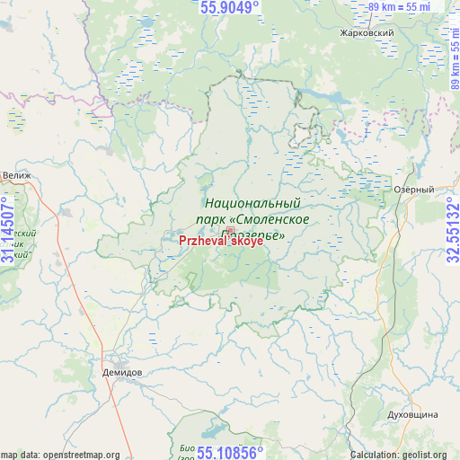
Przheval’skoye GPS coordinates[2]
55° 30' 31.464" North, 31° 50' 53.484" East
| Map corner | latitude | longitude |
|---|---|---|
| Upper-left | 55.9049°, | 31.14507° |
| Center: | 55.50874°, | 31.84819° |
| Lower-right: | 55.10856°, | 32.55132° |
| Map W x H: | 88.5×88.5 km | = 55×55mi |
| max Lat: | 73.50819° ⇑41.7% North |
| Przheval’skoye: | 55.50874° |
| min Lat: | ⇓58.3% South 41.28413° |
| min Long | Przheval’skoy | max Long |
| -179.12198° | 31.84819° | 179.35046° |
| W 6.3%⇐ | ⇒93.7% E |
Elevation
Elevation of Przheval’skoye is 201 m = 659 ft, and this is 1.6 m = 5 ft below average elevation for this country.
| Max E: |
2518 m = 8261 ft | 28.8% |
| Avg. | 202.6 m = 665 ft | |
| Przheval’skoye | 201 m = 659 ft | |
Min E: |
-28 m = -92 ft | 71.2% |
See also: Russia elevation on elevation.city.
Geographical zone
Przheval’skoye is located in North temperate zone (between Tropic of Cancer and the Arctic Circle). Distance of this North polar circle is 1229.2 km =763.8 mi to North.| Distance of | km | miles | from Przheval’skoye |
|---|---|---|---|
| North Pole | 3835.1 | 2383 | to North |
| Arctic Circle | 1229.2 | 763.8 | to North |
| Tropic Cancer | 3566.1 | 2215.9 | to South |
| Equator | 6172 | 3835.1 | to South |


Nearby cities:
15 places around Przheval’skoye: (largest is in red/bold)
• Belyy
77.8 km =48.3 mi,  61°
61°
• Demidov
33.8 km =21 mi,  218°
218°
• Dukhovshchina
50.1 km =31.1 mi,  134°
134°
• Golynki
76.9 km =47.8 mi,  202°
202°
• Kardymovo
78.1 km =48.5 mi,  151°
151°
• Katyn'
82.2 km =51.1 mi,  187°
187°
• Ozërnyy
36.4 km =22.6 mi,  77°
77°
• Pechersk
73.8 km =45.9 mi,  170°
170°
• Rudnya
78.7 km =48.9 mi, 217°
• Smolensk
81.7 km =50.8 mi, 171°
• Usvyaty
73.6 km =45.7 mi,  290°
290°
• Velizh
42.4 km =26.3 mi,  284°
284°
• Yartsevo
72.8 km =45.2 mi, 132°
• Zapadnaya Dvina
84.6 km =52.6 mi,  9°
9°
• Zharkovskiy
46.1 km =28.6 mi,  34°
34°
Sources, notices
• [Note1] Compared only with cities in Russia existing in our database
• [Src1] Map data: © OpenStreetMap contributors (CC-BY-SA)
• [Src2] Other city data from geonames.org with taken over terms of usage.
• [Src3] Geographical zone / Annual Mean Temperature by Robert A. Rohde @ Wikipedia
