Kardymovo geodata
Kardymovo (Smolensk) is a populated place; located in Russia in Europe/Moscow (GMT+3) time zone. With population of 4,951 people, there are 2685 cities with bigger population in this country. Compared to other cities in Russia, 52% of cities are located further ↓South; 92.7% of cities are located further →East and 69.2% of cities have lower elevation than Kardymovo. Note1


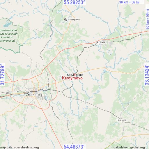
Kardymovo GPS coordinates[2]
54° 53' 24.576" North, 32° 25' 51.996" East
| Map corner | latitude | longitude |
|---|---|---|
| Upper-left | 55.29253°, | 31.72799° |
| Center: | 54.89016°, | 32.43111° |
| Lower-right: | 54.48373°, | 33.13424° |
| Map W x H: | 89.9×89.9 km | = 55.9×55.9mi |
| max Lat: | 73.50819° ⇑48% North |
| Kardymovo: | 54.89016° |
| min Lat: | ⇓52% South 41.28413° |
| min Long | Kardymovo | max Long |
| -179.12198° | 32.43111° | 179.35046° |
| W 7.3%⇐ | ⇒92.7% E |
Elevation
Elevation of Kardymovo is 195 m = 640 ft, and this is 7.6 m = 25 ft below average elevation for this country.
| Max E: |
2518 m = 8261 ft | 30.8% |
| Avg. | 202.6 m = 665 ft | |
| Kardymovo | 195 m = 640 ft | |
Min E: |
-28 m = -92 ft | 69.2% |
See also: Russia elevation on elevation.city.
Geographical zone
Kardymovo is located in North temperate zone (between Tropic of Cancer and the Arctic Circle). Distance of this North polar circle is 1298 km =806.5 mi to North.| Distance of | km | miles | from Kardymovo |
|---|---|---|---|
| North Pole | 3903.8 | 2425.7 | to North |
| Arctic Circle | 1298 | 806.5 | to North |
| Tropic Cancer | 3497.3 | 2173.1 | to South |
| Equator | 6103.2 | 3792.4 | to South |


Nearby cities:
15 places around Kardymovo: (largest is in red/bold)
• Dorogobuzh
55.4 km =34.4 mi,  87°
87°
• Dukhovshchina
33.6 km =20.9 mi,  357°
357°
• Glinka
39.9 km =24.8 mi,  134°
134°
• Golynki
66.9 km =41.6 mi,  268°
268°
• Katyn'
49.1 km =30.5 mi,  254°
254°
• Monastyrshchina
71.2 km =44.2 mi,  212°
212°
• Pechersk
25.9 km =16.1 mi,  260°
260°
• Pochinok
53.7 km =33.4 mi,  179°
179°
• Safonovo
56.7 km =35.2 mi,  64°
64°
• Shatalovo
61.8 km =38.4 mi, 179°
• Smolensk
27.8 km =17.3 mi,  244°
244°
• Talashkino
30.6 km =19 mi, 211°
• Verkhnedneprovskiy
59.3 km =36.8 mi,  80°
80°
• Yartsevo
25.9 km =16.1 mi,  40°
40°
• Yel’nya
59.4 km =36.9 mi, 125°
Sources, notices
• [Note1] Compared only with cities in Russia existing in our database
• [Src1] Map data: © OpenStreetMap contributors (CC-BY-SA)
• [Src2] Other city data from geonames.org with taken over terms of usage.
• [Src3] Geographical zone / Annual Mean Temperature by Robert A. Rohde @ Wikipedia
