Podlesnoye geodata
Podlesnoye (Saratovskaya Oblast) is a populated place; located in Russia in Europe/Saratov (GMT+4) time zone. With population of 4,149 people, there are 3033 cities with bigger population in this country. Compared to other cities in Russia, 70.4% of cities are located further ↑North; 56% of cities are located further ←West and 90.5% of cities have higher elevation than Podlesnoye. Note1


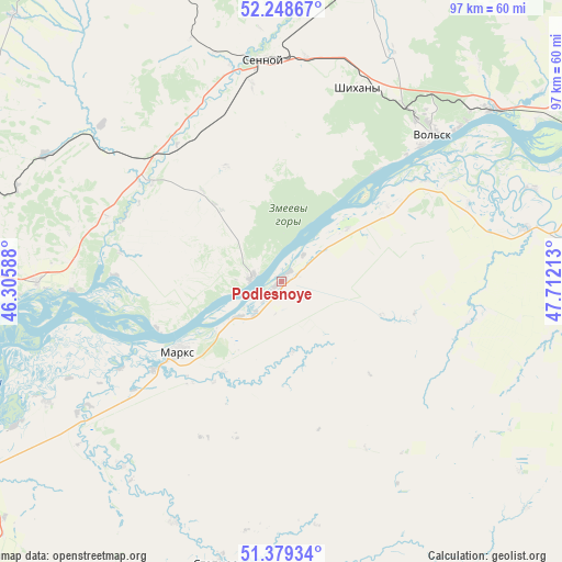
Podlesnoye GPS coordinates[2]
51° 48' 57.96" North, 47° 0' 32.4" East
| Map corner | latitude | longitude |
|---|---|---|
| Upper-left | 52.24867°, | 46.30588° |
| Center: | 51.8161°, | 47.009° |
| Lower-right: | 51.37934°, | 47.71213° |
| Map W x H: | 96.7×96.7 km | = 60.1×60.1mi |
| max Lat: | 73.50819° ⇑70.4% North |
| Podlesnoye: | 51.8161° |
| min Lat: | ⇓29.6% South 41.28413° |
| min Long | Podlesnoye | max Long |
| -179.12198° | 47.009° | 179.35046° |
| W 56%⇐ | ⇒44% E |
Elevation
Elevation of Podlesnoye is 27 m = 89 ft, and this is 175.6 m = 576 ft below average elevation for this country.
| Max E: |
2518 m = 8261 ft | 90.5% |
| Avg. | 202.6 m = 665 ft | |
| Podlesnoye | 27 m = 89 ft | |
Min E: |
-28 m = -92 ft | 9.5% |
See also: Russia elevation on elevation.city.
Geographical zone
Podlesnoye is located in North temperate zone (between Tropic of Cancer and the Arctic Circle). Distance of this North polar circle is 1639.8 km =1018.9 mi to North.| Distance of | km | miles | from Podlesnoye |
|---|---|---|---|
| North Pole | 4245.7 | 2638.2 | to North |
| Arctic Circle | 1639.8 | 1018.9 | to North |
| Tropic Cancer | 3155.5 | 1960.7 | to South |
| Equator | 5761.4 | 3580 | to South |


Nearby cities:
15 places around Podlesnoye: (largest is in red/bold)
• Balakovo
59.2 km =36.8 mi,  66°
66°
• Krasnyy Yar
45.5 km =28.3 mi,  242°
242°
• Marks
21.4 km =13.3 mi, 236°
• Privolzhskoye
24 km =14.9 mi,  234°
234°
• Pushkino
64.7 km =40.2 mi,  182°
182°
• Sennoy
37.4 km =23.2 mi,  355°
355°
• Shikhany
36 km =22.4 mi,  21°
21°
• Shumeyka
59.5 km =37 mi, 241°
• Sinodskoye
30.4 km =18.9 mi,  310°
310°
• Sovetskoye
45.4 km =28.2 mi,  203°
203°
• Stepnoye
49.8 km =30.9 mi,  192°
192°
• Tersa
47.2 km =29.3 mi,  50°
50°
• Vol’sk
36 km =22.4 mi,  44°
44°
• Voskresenskoye
5.2 km =3.2 mi,  280°
280°
• Yelshanka
41.9 km =26 mi,  269°
269°
Sources, notices
• [Note1] Compared only with cities in Russia existing in our database
• [Src1] Map data: © OpenStreetMap contributors (CC-BY-SA)
• [Src2] Other city data from geonames.org with taken over terms of usage.
• [Src3] Geographical zone / Annual Mean Temperature by Robert A. Rohde @ Wikipedia
