Shumeyka geodata
Shumeyka (Saratovskaya Oblast) is a populated place; located in Russia in Europe/Saratov (GMT+4) time zone. With population of 1,370 people, there are 4441 cities with bigger population in this country. Compared to other cities in Russia, 72.1% of cities are located further ↑North; 53.4% of cities are located further ←West and 92.9% of cities have higher elevation than Shumeyka. Note1


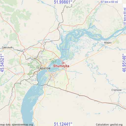
Shumeyka GPS coordinates[2]
51° 33' 48.996" North, 46° 14' 53.988" East
| Map corner | latitude | longitude |
|---|---|---|
| Upper-left | 51.99861°, | 45.54521° |
| Center: | 51.56361°, | 46.24833° |
| Lower-right: | 51.12441°, | 46.95146° |
| Map W x H: | 97.2×97.2 km | = 60.4×60.4mi |
| max Lat: | 73.50819° ⇑72.1% North |
| Shumeyka: | 51.56361° |
| min Lat: | ⇓27.9% South 41.28413° |
| min Long | Shumeyka | max Long |
| -179.12198° | 46.24833° | 179.35046° |
| W 53.4%⇐ | ⇒46.6% E |
Elevation
Elevation of Shumeyka is 18 m = 59 ft, and this is 184.6 m = 606 ft below average elevation for this country.
| Max E: |
2518 m = 8261 ft | 92.9% |
| Avg. | 202.6 m = 665 ft | |
| Shumeyka | 18 m = 59 ft | |
Min E: |
-28 m = -92 ft | 7.1% |
See also: Russia elevation on elevation.city.
Geographical zone
Shumeyka is located in North temperate zone (between Tropic of Cancer and the Arctic Circle). Distance of this North polar circle is 1667.8 km =1036.3 mi to North.| Distance of | km | miles | from Shumeyka |
|---|---|---|---|
| North Pole | 4273.7 | 2655.6 | to North |
| Arctic Circle | 1667.8 | 1036.3 | to North |
| Tropic Cancer | 3127.4 | 1943.3 | to South |
| Equator | 5733.3 | 3562.5 | to South |


Nearby cities:
15 places around Shumeyka: (largest is in red/bold)
• Engel’s
13.3 km =8.3 mi,  228°
228°
• Krasnyy Oktyabr’
37.7 km =23.4 mi,  266°
266°
• Krasnyy Yar
14 km =8.7 mi,  58°
58°
• Marks
38.2 km =23.7 mi, 64°
• Privolzhskiy
22 km =13.7 mi,  218°
218°
• Privolzhskoye
35.8 km =22.2 mi,  66°
66°
• Saratov
16.8 km =10.4 mi,  261°
261°
• Sinodskoye
55.8 km =34.7 mi,  31°
31°
• Sokolovyy
28.7 km =17.8 mi, 271°
• Sovetskoye
36.7 km =22.8 mi,  111°
111°
• Stepnoye
46.4 km =28.8 mi,  116°
116°
• Svetlyy
44.4 km =27.6 mi,  286°
286°
• Tatishchevo
46.6 km =29 mi,  284°
284°
• Voskresenskoye
55.5 km =34.5 mi, 58°
• Yelshanka
29.7 km =18.5 mi,  20°
20°
Sources, notices
• [Note1] Compared only with cities in Russia existing in our database
• [Src1] Map data: © OpenStreetMap contributors (CC-BY-SA)
• [Src2] Other city data from geonames.org with taken over terms of usage.
• [Src3] Geographical zone / Annual Mean Temperature by Robert A. Rohde @ Wikipedia
