Pervomayskiy geodata
Pervomayskiy (Tula) is a section of populated place; located in Russia in Europe/Moscow (GMT+3) time zone. With population of 10,885 people, there are 1389 cities with bigger population in this country. Compared to other cities in Russia, 54.8% of cities are located further ↑North; 81.7% of cities are located further →East and 78.7% of cities have lower elevation than Pervomayskiy. Note1


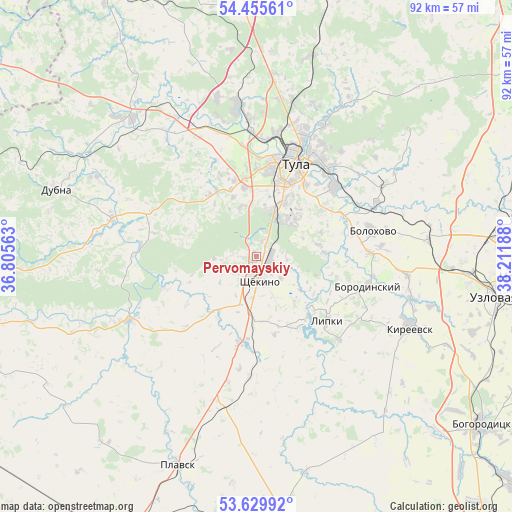
Pervomayskiy GPS coordinates[2]
54° 2' 41.352" North, 37° 30' 31.5" East
| Map corner | latitude | longitude |
|---|---|---|
| Upper-left | 54.45561°, | 36.80563° |
| Center: | 54.04482°, | 37.50875° |
| Lower-right: | 53.62992°, | 38.21188° |
| Map W x H: | 91.8×91.8 km | = 57×57mi |
| max Lat: | 73.50819° ⇑54.8% North |
| Pervomayskiy: | 54.04482° |
| min Lat: | ⇓45.2% South 41.28413° |
| min Long | Pervomayskiy | max Long |
| -179.12198° | 37.50875° | 179.35046° |
| W 18.3%⇐ | ⇒81.7% E |
Elevation
Elevation of Pervomayskiy is 239 m = 784 ft, and this is 36.4 m = 119 ft above average elevation for this country.
| Max E: |
2518 m = 8261 ft | 21.3% |
| Pervomayskiy | 239 m 784 ft | |
| Avg. | 202.6 m = 665 ft | |
Min E: |
-28 m = -92 ft | 78.7% |
See also: Russia elevation on elevation.city.
Geographical zone
Pervomayskiy is located in North temperate zone (between Tropic of Cancer and the Arctic Circle). Distance of this North polar circle is 1392 km =864.9 mi to North.| Distance of | km | miles | from Pervomayskiy |
|---|---|---|---|
| North Pole | 3997.8 | 2484.1 | to North |
| Arctic Circle | 1392 | 864.9 | to North |
| Tropic Cancer | 3403.3 | 2114.7 | to South |
| Equator | 6009.2 | 3733.9 | to South |


Nearby cities:
15 places around Pervomayskiy: (largest is in red/bold)
• Barsuki
24.6 km =15.3 mi,  356°
356°
• Bolokhovo
21.3 km =13.2 mi,  78°
78°
• Borodinskiy
20.8 km =12.9 mi,  104°
104°
• Gorelki
24.4 km =15.2 mi,  15°
15°
• Kosaya Gora
8.6 km =5.3 mi, 15°
• Krapivna
25.6 km =15.9 mi,  243°
243°
• Leninskiy
27.2 km =16.9 mi,  353°
353°
• Lomintsevskiy
12.1 km =7.5 mi,  122°
122°
• Mendeleyevskiy
11.5 km =7.1 mi,  26°
26°
• Priupskiy
21.1 km =13.1 mi,  135°
135°
• Rozhdestvenskiy
28.2 km =17.5 mi,  8°
8°
• Shchëkino
4.5 km =2.8 mi,  168°
168°
• Skuratovskiy
8.8 km =5.5 mi,  44°
44°
• Tula
18.3 km =11.4 mi, 22°
• Yasnaya Polyana
2.8 km =1.7 mi, 21°
Sources, notices
• [Note1] Compared only with cities in Russia existing in our database
• [Src1] Map data: © OpenStreetMap contributors (CC-BY-SA)
• [Src2] Other city data from geonames.org with taken over terms of usage.
• [Src3] Geographical zone / Annual Mean Temperature by Robert A. Rohde @ Wikipedia
