Kronshtadt geodata
Kronshtadt (St.-Petersburg) is a populated place; located in Russia in Europe/Moscow (GMT+3) time zone. With population of 43,005 people, there are 488 cities with bigger population in this country. Compared to other cities in Russia, 90.3% of cities are located further ↓South; 97.5% of cities are located further →East and 96.8% of cities have higher elevation than Kronshtadt. Note1


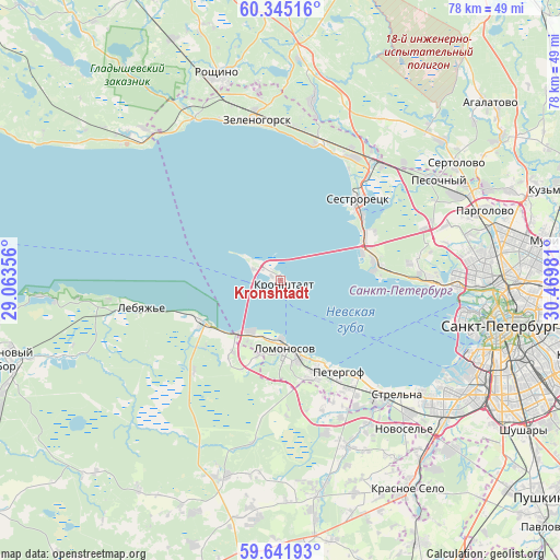
Kronshtadt GPS coordinates[2]
59° 59' 43.476" North, 29° 46' 0.048" East
| Map corner | latitude | longitude |
|---|---|---|
| Upper-left | 60.34516°, | 29.06356° |
| Center: | 59.99541°, | 29.76668° |
| Lower-right: | 59.64193°, | 30.46981° |
| Map W x H: | 78.2×78.2 km | = 48.6×48.6mi |
| max Lat: | 73.50819° ⇑9.7% North |
| Kronshtadt: | 59.99541° |
| min Lat: | ⇓90.3% South 41.28413° |
| min Long | Kronshtadt | max Long |
| -179.12198° | 29.76668° | 179.35046° |
| W 2.5%⇐ | ⇒97.5% E |
Elevation
Elevation of Kronshtadt is 8 m = 26 ft, and this is 194.6 m = 638 ft below average elevation for this country.
| Max E: |
2518 m = 8261 ft | 96.8% |
| Avg. | 202.6 m = 665 ft | |
| Kronshtadt | 8 m = 26 ft | |
Min E: |
-28 m = -92 ft | 3.2% |
See also: Kronshtadt elevation on elevation.city.
Geographical zone
Kronshtadt is located in North temperate zone (between Tropic of Cancer and the Arctic Circle). Distance of this North polar circle is 730.3 km =453.8 mi to North.| Distance of | km | miles | from Kronshtadt |
|---|---|---|---|
| North Pole | 3336.2 | 2073 | to North |
| Arctic Circle | 730.3 | 453.8 | to North |
| Tropic Cancer | 4064.9 | 2525.8 | to South |
| Equator | 6670.9 | 4145.1 | to South |


Nearby cities:
15 places around Kronshtadt: (largest is in red/bold)
• Aleksandrovskaya
13.4 km =8.3 mi,  62°
62°
• Bol’shaya Izhora
12.3 km =7.6 mi,  238°
238°
• Gorskaya
12.7 km =7.9 mi, 63°
• Kurortnyy
20.5 km =12.7 mi,  22°
22°
• Lebyazh’ye
19.9 km =12.4 mi,  259°
259°
• Lisiy Nos
14.3 km =8.9 mi,  80°
80°
• Lomonosov
9.9 km =6.2 mi,  178°
178°
• Ol’gino
19.5 km =12.1 mi,  85°
85°
• Ol’gino
19.6 km =12.2 mi,  153°
153°
• Peterhof
14.5 km =9 mi, 149°
• Petrodvorets
11.3 km =7 mi,  170°
170°
• Razliv
14.7 km =9.1 mi,  50°
50°
• Repino
20.5 km =12.7 mi, 16°
• Sestroretsk
15.8 km =9.8 mi,  43°
43°
• Tarkhovka
14 km =8.7 mi, 55°
Sources, notices
• [Note1] Compared only with cities in Russia existing in our database
• [Src1] Map data: © OpenStreetMap contributors (CC-BY-SA)
• [Src2] Other city data from geonames.org with taken over terms of usage.
• [Src3] Geographical zone / Annual Mean Temperature by Robert A. Rohde @ Wikipedia
