Il’ichëvo geodata
Il’ichëvo (Leningradskaya Oblast') is a populated place; located in Russia in Europe/Moscow (GMT+3) time zone. With population of 1,400 people, there are 4429 cities with bigger population in this country. Compared to other cities in Russia, 91.6% of cities are located further ↓South; 97.6% of cities are located further →East and 78% of cities have higher elevation than Il’ichëvo. Note1


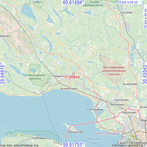
Il’ichëvo GPS coordinates[2]
60° 16' 5.088" North, 29° 45' 8.28" East
| Map corner | latitude | longitude |
|---|---|---|
| Upper-left | 60.61494°, | 29.04918° |
| Center: | 60.26808°, | 29.7523° |
| Lower-right: | 59.91751°, | 30.45543° |
| Map W x H: | 77.5×77.5 km | = 48.2×48.2mi |
| max Lat: | 73.50819° ⇑8.4% North |
| Il’ichëvo: | 60.26808° |
| min Lat: | ⇓91.6% South 41.28413° |
| min Long | Il’ichëvo | max Long |
| -179.12198° | 29.7523° | 179.35046° |
| W 2.4%⇐ | ⇒97.6% E |
Elevation
Elevation of Il’ichëvo is 77 m = 253 ft, and this is 125.6 m = 412 ft below average elevation for this country.
| Max E: |
2518 m = 8261 ft | 78% |
| Avg. | 202.6 m = 665 ft | |
| Il’ichëvo | 77 m = 253 ft | |
Min E: |
-28 m = -92 ft | 22% |
See also: Russia elevation on elevation.city.
Geographical zone
Il’ichëvo is located in North temperate zone (between Tropic of Cancer and the Arctic Circle). Distance of this North polar circle is 700 km =435 mi to North.| Distance of | km | miles | from Il’ichëvo |
|---|---|---|---|
| North Pole | 3305.9 | 2054.2 | to North |
| Arctic Circle | 700 | 435 | to North |
| Tropic Cancer | 4095.3 | 2544.7 | to South |
| Equator | 6701.2 | 4163.9 | to South |


Nearby cities:
15 places around Il’ichëvo: (largest is in red/bold)
• Beloostrov
18.9 km =11.7 mi,  133°
133°
• Komarovo
9.6 km =6 mi,  161°
161°
• Kurortnyy
14.3 km =8.9 mi,  142°
142°
• Leninskoye
7.5 km =4.7 mi, 135°
• Molodezhnoye
15.2 km =9.4 mi,  239°
239°
• Pervomayskoye
10.1 km =6.3 mi,  356°
356°
• Razliv
24.3 km =15.1 mi,  149°
149°
• Repino
12.5 km =7.8 mi, 148°
• Roshchino
8.1 km =5 mi,  257°
257°
• Sestroretsk
22.2 km =13.8 mi, 148°
• Smolyachkovo
18.1 km =11.2 mi, 237°
• Solnechnoye
16.5 km =10.3 mi, 139°
• Ushkovo
10.2 km =6.3 mi,  223°
223°
• Yakovlevo
14.9 km =9.3 mi,  281°
281°
• Zelenogorsk
8.1 km =5 mi,  200°
200°
Sources, notices
• [Note1] Compared only with cities in Russia existing in our database
• [Src1] Map data: © OpenStreetMap contributors (CC-BY-SA)
• [Src2] Other city data from geonames.org with taken over terms of usage.
• [Src3] Geographical zone / Annual Mean Temperature by Robert A. Rohde @ Wikipedia
