Ostashëvo geodata
Ostashëvo (Moscow Oblast) is a populated place; located in Russia in Europe/Moscow (GMT+3) time zone. With population of 2,743 people, there are 3877 cities with bigger population in this country. Compared to other cities in Russia, 64.5% of cities are located further ↓South; 87.7% of cities are located further →East and 67.7% of cities have lower elevation than Ostashëvo. Note1


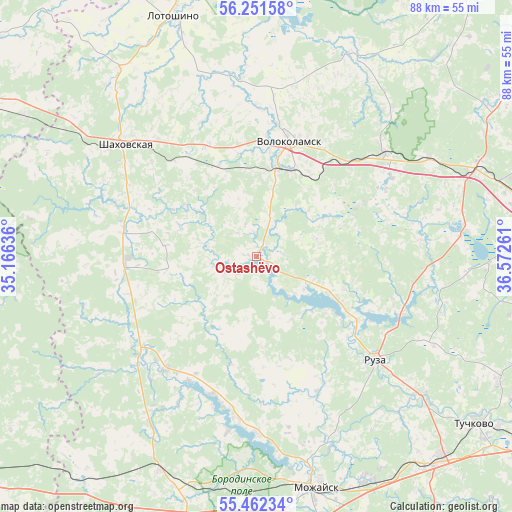
Ostashëvo GPS coordinates[2]
55° 51' 32.256" North, 35° 52' 10.128" East
| Map corner | latitude | longitude |
|---|---|---|
| Upper-left | 56.25158°, | 35.16636° |
| Center: | 55.85896°, | 35.86948° |
| Lower-right: | 55.46234°, | 36.57261° |
| Map W x H: | 87.8×87.8 km | = 54.6×54.6mi |
| max Lat: | 73.50819° ⇑35.5% North |
| Ostashëvo: | 55.85896° |
| min Lat: | ⇓64.5% South 41.28413° |
| min Long | Ostashëvo | max Long |
| -179.12198° | 35.86948° | 179.35046° |
| W 12.3%⇐ | ⇒87.7% E |
Elevation
Elevation of Ostashëvo is 190 m = 623 ft, and this is 12.6 m = 41 ft below average elevation for this country.
| Max E: |
2518 m = 8261 ft | 32.3% |
| Avg. | 202.6 m = 665 ft | |
| Ostashëvo | 190 m = 623 ft | |
Min E: |
-28 m = -92 ft | 67.7% |
See also: Russia elevation on elevation.city.
Geographical zone
Ostashëvo is located in North temperate zone (between Tropic of Cancer and the Arctic Circle). Distance of this North polar circle is 1190.2 km =739.6 mi to North.| Distance of | km | miles | from Ostashëvo |
|---|---|---|---|
| North Pole | 3796.1 | 2358.8 | to North |
| Arctic Circle | 1190.2 | 739.6 | to North |
| Tropic Cancer | 3605 | 2240 | to South |
| Equator | 6210.9 | 3859.3 | to South |


Nearby cities:
15 places around Ostashëvo: (largest is in red/bold)
• Arkhangel’skoye
33.7 km =20.9 mi,  269°
269°
• Gidrouzel
36.8 km =22.9 mi,  172°
172°
• Knyazh’i Gory
46.5 km =28.9 mi,  301°
301°
• Kur’yanovo
20.6 km =12.8 mi,  334°
334°
• Lotoshino
44.1 km =27.4 mi,  341°
341°
• Mozhaysk
40.9 km =25.4 mi, 166°
• Novopetrovskoye
40.4 km =25.1 mi,  68°
68°
• Rumyantsevo
43.3 km =26.9 mi, 73°
• Ruza
27 km =16.8 mi,  131°
131°
• Shakhovskaya
29.6 km =18.4 mi,  310°
310°
• Sychëvo
24.9 km =15.5 mi,  63°
63°
• Teryayevo
38 km =23.6 mi,  24°
24°
• Uvarovka
40.4 km =25.1 mi,  204°
204°
• Volokolamsk
20.4 km =12.7 mi, 17°
• Yaropolets
30.6 km =19 mi,  355°
355°
Sources, notices
• [Note1] Compared only with cities in Russia existing in our database
• [Src1] Map data: © OpenStreetMap contributors (CC-BY-SA)
• [Src2] Other city data from geonames.org with taken over terms of usage.
• [Src3] Geographical zone / Annual Mean Temperature by Robert A. Rohde @ Wikipedia
