Rumyantsevo geodata
Rumyantsevo (Moscow Oblast) is a populated place; located in Russia in Europe/Moscow (GMT+3) time zone. With population of 7,345 people, there are 1921 cities with bigger population in this country. Compared to other cities in Russia, 66.2% of cities are located further ↓South; 86.1% of cities are located further →East and 74% of cities have lower elevation than Rumyantsevo. Note1


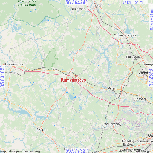
Rumyantsevo GPS coordinates[2]
55° 58' 22.008" North, 36° 32' 3.012" East
| Map corner | latitude | longitude |
|---|---|---|
| Upper-left | 56.36424°, | 35.83105° |
| Center: | 55.97278°, | 36.53417° |
| Lower-right: | 55.57732°, | 37.2373° |
| Map W x H: | 87.5×87.5 km | = 54.4×54.4mi |
| max Lat: | 73.50819° ⇑33.8% North |
| Rumyantsevo: | 55.97278° |
| min Lat: | ⇓66.2% South 41.28413° |
| min Long | Rumyantsevo | max Long |
| -179.12198° | 36.53417° | 179.35046° |
| W 13.9%⇐ | ⇒86.1% E |
Elevation
Elevation of Rumyantsevo is 212 m = 696 ft, and this is 9.4 m = 31 ft above average elevation for this country.
| Max E: |
2518 m = 8261 ft | 26% |
| Rumyantsevo | 212 m 696 ft | |
| Avg. | 202.6 m = 665 ft | |
Min E: |
-28 m = -92 ft | 74% |
See also: Russia elevation on elevation.city.
Geographical zone
Rumyantsevo is located in North temperate zone (between Tropic of Cancer and the Arctic Circle). Distance of this North polar circle is 1177.6 km =731.7 mi to North.| Distance of | km | miles | from Rumyantsevo |
|---|---|---|---|
| North Pole | 3783.5 | 2351 | to North |
| Arctic Circle | 1177.6 | 731.7 | to North |
| Tropic Cancer | 3617.7 | 2247.9 | to South |
| Equator | 6223.6 | 3867.2 | to South |


Nearby cities:
15 places around Rumyantsevo: (largest is in red/bold)
• Istra
21.6 km =13.4 mi,  105°
105°
• Karinskoye
30.8 km =19.1 mi,  161°
161°
• Kolyubakino
33.9 km =21.1 mi,  180°
180°
• Kostrovo
13.3 km =8.3 mi,  131°
131°
• Krivtsovo
29.3 km =18.2 mi,  47°
47°
• Novopetrovskoye
4.5 km =2.8 mi,  299°
299°
• Nudol’
14.2 km =8.8 mi,  355°
355°
• Povarovo
33.7 km =20.9 mi,  71°
71°
• Rozhdestveno
34.7 km =21.6 mi, 112°
• Savvinskaya Sloboda
32.4 km =20.1 mi,  148°
148°
• Snegiri
31.9 km =19.8 mi, 107°
• Sychëvo
19.1 km =11.9 mi,  264°
264°
• Teryayevo
33.5 km =20.8 mi,  310°
310°
• Yershovo
30.4 km =18.9 mi,  138°
138°
• Zvenigorod
33.4 km =20.8 mi, 142°
Sources, notices
• [Note1] Compared only with cities in Russia existing in our database
• [Src1] Map data: © OpenStreetMap contributors (CC-BY-SA)
• [Src2] Other city data from geonames.org with taken over terms of usage.
• [Src3] Geographical zone / Annual Mean Temperature by Robert A. Rohde @ Wikipedia
