Nikulino geodata
Nikulino (Moscow) is a historical populated place; located in Russia in Europe/Moscow (GMT+3) time zone. With population of 30,000 people, there are 646 cities with bigger population in this country. Compared to other cities in Russia, 61% of cities are located further ↓South; 82.3% of cities are located further →East and 64.3% of cities have lower elevation than Nikulino. Note1


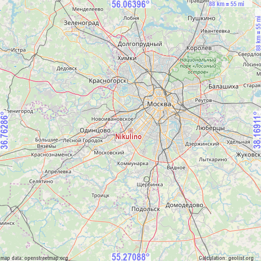
Nikulino GPS coordinates[2]
55° 40' 9.948" North, 37° 27' 57.528" East
| Map corner | latitude | longitude |
|---|---|---|
| Upper-left | 56.06396°, | 36.76286° |
| Center: | 55.66943°, | 37.46598° |
| Lower-right: | 55.27088°, | 38.16911° |
| Map W x H: | 88.2×88.2 km | = 54.8×54.8mi |
| max Lat: | 73.50819° ⇑39% North |
| Nikulino: | 55.66943° |
| min Lat: | ⇓61% South 41.28413° |
| min Long | Nikulino | max Long |
| -179.12198° | 37.46598° | 179.35046° |
| W 17.7%⇐ | ⇒82.3% E |
Elevation
Elevation of Nikulino is 180 m = 591 ft, and this is 22.6 m = 74 ft below average elevation for this country.
| Max E: |
2518 m = 8261 ft | 35.7% |
| Avg. | 202.6 m = 665 ft | |
| Nikulino | 180 m = 591 ft | |
Min E: |
-28 m = -92 ft | 64.3% |
See also: Russia elevation on elevation.city.
Geographical zone
Nikulino is located in North temperate zone (between Tropic of Cancer and the Arctic Circle). Distance of this North polar circle is 1211.3 km =752.7 mi to North.| Distance of | km | miles | from Nikulino |
|---|---|---|---|
| North Pole | 3817.2 | 2371.9 | to North |
| Arctic Circle | 1211.3 | 752.7 | to North |
| Tropic Cancer | 3583.9 | 2226.9 | to South |
| Equator | 6189.9 | 3846.2 | to South |


Nearby cities:
15 places around Nikulino: (largest is in red/bold)
• Amin’yevo
3.4 km =2.1 mi,  0°
0°
• Cherëmushki
6 km =3.7 mi,  94°
94°
• Davydkovo
5.4 km =3.4 mi, 4°
• Kastanayevo
5.7 km =3.5 mi,  22°
22°
• Matveyevskoye
4.7 km =2.9 mi,  6°
6°
• Mikhalkovo
2.6 km =1.6 mi,  307°
307°
• Mosrentgen
5.5 km =3.4 mi,  181°
181°
• Nikol’skoye
1.9 km =1.2 mi,  35°
35°
• Ochakovo-Matveyevskoye
2.1 km =1.3 mi,  323°
323°
• Ramenki
4 km =2.5 mi,  32°
32°
• Semënovskoye
5.5 km =3.4 mi,  73°
73°
• Troparëvo
1.9 km =1.2 mi,  140°
140°
• Tyoply Stan
5.7 km =3.5 mi,  162°
162°
• Vostryakovo
1 km =0.6 mi,  252°
252°
• Zarech’ye
5 km =3.1 mi,  292°
292°
Sources, notices
• [Note1] Compared only with cities in Russia existing in our database
• [Src1] Map data: © OpenStreetMap contributors (CC-BY-SA)
• [Src2] Other city data from geonames.org with taken over terms of usage.
• [Src3] Geographical zone / Annual Mean Temperature by Robert A. Rohde @ Wikipedia
