Semënovskoye geodata
Semënovskoye (Moscow Oblast) is a section of populated place; located in Russia in Europe/Moscow (GMT+3) time zone. With population of 50,000 people, there are 416 cities with bigger population in this country. Compared to other cities in Russia, 61.2% of cities are located further ↓South; 81.3% of cities are located further →East and 62.4% of cities have lower elevation than Semënovskoye. Note1


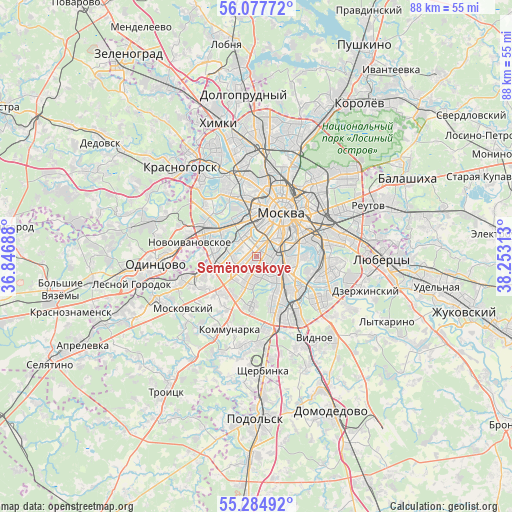
Semënovskoye GPS coordinates[2]
55° 40' 59.988" North, 37° 33' 0" East
| Map corner | latitude | longitude |
|---|---|---|
| Upper-left | 56.07772°, | 36.84688° |
| Center: | 55.68333°, | 37.55° |
| Lower-right: | 55.28492°, | 38.25313° |
| Map W x H: | 88.2×88.1 km | = 54.8×54.7mi |
| max Lat: | 73.50819° ⇑38.8% North |
| Semënovskoye: | 55.68333° |
| min Lat: | ⇓61.2% South 41.28413° |
| min Long | Semënovskoye | max Long |
| -179.12198° | 37.55° | 179.35046° |
| W 18.7%⇐ | ⇒81.3% E |
Elevation
Elevation of Semënovskoye is 175 m = 574 ft, and this is 27.6 m = 91 ft below average elevation for this country.
| Max E: |
2518 m = 8261 ft | 37.6% |
| Avg. | 202.6 m = 665 ft | |
| Semënovskoye | 175 m = 574 ft | |
Min E: |
-28 m = -92 ft | 62.4% |
See also: Semënovskoye elevation on elevation.city.
Geographical zone
Semënovskoye is located in North temperate zone (between Tropic of Cancer and the Arctic Circle). Distance of this North polar circle is 1209.8 km =751.7 mi to North.| Distance of | km | miles | from Semënovskoye |
|---|---|---|---|
| North Pole | 3815.7 | 2371 | to North |
| Arctic Circle | 1209.8 | 751.7 | to North |
| Tropic Cancer | 3585.5 | 2227.9 | to South |
| Equator | 6191.4 | 3847.2 | to South |


Nearby cities:
15 places around Semënovskoye: (largest is in red/bold)
• Amin’yevo
5.5 km =3.4 mi,  289°
289°
• Cherëmushki
2.2 km =1.4 mi,  161°
161°
• Kastanayevo
4.9 km =3 mi,  319°
319°
• Kotlovka
4.3 km =2.7 mi,  128°
128°
• Leninskiye Gory
2.1 km =1.3 mi,  29°
29°
• Luzhniki
3.6 km =2.2 mi,  3°
3°
• Matveyevskoye
5.6 km =3.5 mi,  303°
303°
• Nagornyy
5.6 km =3.5 mi, 131°
• Nikol’skoye
4.2 km =2.6 mi,  270°
270°
• Nikulino
5.5 km =3.4 mi,  253°
253°
• Novyye Cherëmushki
2.8 km =1.7 mi,  48°
48°
• Ramenki
3.6 km =2.2 mi, 300°
• Troparëvo
5.1 km =3.2 mi,  233°
233°
• Vorob’yovo
3.9 km =2.4 mi,  344°
344°
• Zyuzino
3.2 km =2 mi, 159°
Sources, notices
• [Note1] Compared only with cities in Russia existing in our database
• [Src1] Map data: © OpenStreetMap contributors (CC-BY-SA)
• [Src2] Other city data from geonames.org with taken over terms of usage.
• [Src3] Geographical zone / Annual Mean Temperature by Robert A. Rohde @ Wikipedia
