Nesterov geodata
Nesterov (Kaliningrad) is a seat of a second-order administrative division; located in Russia in Europe/Kaliningrad (GMT+2) time zone. With population of 5,071 people, there are 2628 cities with bigger population in this country. Compared to other cities in Russia, 50.1% of cities are located further ↑North; 99.2% of cities are located further →East and 80.9% of cities have higher elevation than Nesterov. Note1


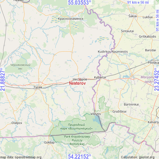
Nesterov GPS coordinates[2]
54° 37' 50.016" North, 22° 34' 17.004" East
| Map corner | latitude | longitude |
|---|---|---|
| Upper-left | 55.03553°, | 21.86827° |
| Center: | 54.63056°, | 22.57139° |
| Lower-right: | 54.22152°, | 23.27452° |
| Map W x H: | 90.5×90.5 km | = 56.2×56.2mi |
| max Lat: | 73.50819° ⇑50.1% North |
| Nesterov: | 54.63056° |
| min Lat: | ⇓49.9% South 41.28413° |
| min Long | Nesterov | max Long |
| -179.12198° | 22.57139° | 179.35046° |
| W 0.8%⇐ | ⇒99.2% E |
Elevation
Elevation of Nesterov is 68 m = 223 ft, and this is 134.6 m = 442 ft below average elevation for this country.
| Max E: |
2518 m = 8261 ft | 80.9% |
| Avg. | 202.6 m = 665 ft | |
| Nesterov | 68 m = 223 ft | |
Min E: |
-28 m = -92 ft | 19.1% |
See also: Russia elevation on elevation.city.
Geographical zone
Nesterov is located in North temperate zone (between Tropic of Cancer and the Arctic Circle). Distance of this North polar circle is 1326.8 km =824.4 mi to North.| Distance of | km | miles | from Nesterov |
|---|---|---|---|
| North Pole | 3932.7 | 2443.7 | to North |
| Arctic Circle | 1326.8 | 824.4 | to North |
| Tropic Cancer | 3468.4 | 2155.2 | to South |
| Equator | 6074.3 | 3774.4 | to South |


Nearby cities:
15 places around Nesterov: (largest is in red/bold)
• Chernyakhovsk
48.6 km =30.2 mi,  270°
270°
• Gusev
24.3 km =15.1 mi,  259°
259°
• Gvardeysk
96.9 km =60.2 mi, 271°
• Krasnoznamensk
35 km =21.7 mi,  351°
351°
• Neman
56.6 km =35.2 mi,  321°
321°
• Nizov’ye
118.2 km =73.4 mi, 273°
• Otradnoye
54.2 km =33.7 mi, 258°
• Ozërsk
43.6 km =27.1 mi,  235°
235°
• Polessk
97.7 km =60.7 mi,  285°
285°
• Pravdinsk
102.4 km =63.6 mi, 258°
• Rybachiy
124.5 km =77.4 mi,  297°
297°
• Slavsk
73.3 km =45.5 mi,  308°
308°
• Sovetsk
67.1 km =41.7 mi, 318°
• Zheleznodorozhnyy
87.1 km =54.1 mi,  249°
249°
• Znamensk
86.5 km =53.7 mi, 268°
Sources, notices
• [Note1] Compared only with cities in Russia existing in our database
• [Src1] Map data: © OpenStreetMap contributors (CC-BY-SA)
• [Src2] Other city data from geonames.org with taken over terms of usage.
• [Src3] Geographical zone / Annual Mean Temperature by Robert A. Rohde @ Wikipedia
