Neman geodata
Neman (Kaliningrad) is a seat of a second-order administrative division; located in Russia in Europe/Kaliningrad (GMT+2) time zone. With population of 12,507 people, there are 1232 cities with bigger population in this country. Compared to other cities in Russia, 53.6% of cities are located further ↓South; 99.2% of cities are located further →East and 88.8% of cities have higher elevation than Neman. Note1


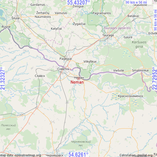
Neman GPS coordinates[2]
55° 1' 51.996" North, 22° 1' 35.004" East
| Map corner | latitude | longitude |
|---|---|---|
| Upper-left | 55.43207°, | 21.32327° |
| Center: | 55.03111°, | 22.02639° |
| Lower-right: | 54.6261°, | 22.72952° |
| Map W x H: | 89.6×89.6 km | = 55.7×55.7mi |
| max Lat: | 73.50819° ⇑46.4% North |
| Neman: | 55.03111° |
| min Lat: | ⇓53.6% South 41.28413° |
| min Long | Neman | max Long |
| -179.12198° | 22.02639° | 179.35046° |
| W 0.8%⇐ | ⇒99.2% E |
Elevation
Elevation of Neman is 33 m = 108 ft, and this is 169.6 m = 556 ft below average elevation for this country.
| Max E: |
2518 m = 8261 ft | 88.8% |
| Avg. | 202.6 m = 665 ft | |
| Neman | 33 m = 108 ft | |
Min E: |
-28 m = -92 ft | 11.2% |
See also: Russia elevation on elevation.city.
Geographical zone
Neman is located in North temperate zone (between Tropic of Cancer and the Arctic Circle). Distance of this North polar circle is 1282.3 km =796.8 mi to North.| Distance of | km | miles | from Neman |
|---|---|---|---|
| North Pole | 3888.2 | 2416 | to North |
| Arctic Circle | 1282.3 | 796.8 | to North |
| Tropic Cancer | 3513 | 2182.9 | to South |
| Equator | 6118.9 | 3802.1 | to South |


Nearby cities:
15 places around Neman: (largest is in red/bold)
• Chernyakhovsk
46.2 km =28.7 mi,  196°
196°
• Gusev
50 km =31.1 mi,  167°
167°
• Gvardeysk
74.9 km =46.5 mi,  235°
235°
• Krasnoznamensk
31.2 km =19.4 mi,  108°
108°
• Lesnoy
89.8 km =55.8 mi,  268°
268°
• Nesterov
56.6 km =35.2 mi,  141°
141°
• Nizov’ye
90.2 km =56 mi,  246°
246°
• Otradnoye
58.2 km =36.2 mi, 197°
• Ozërsk
69 km =42.9 mi,  180°
180°
• Polessk
61.9 km =38.5 mi, 252°
• Rybachiy
76 km =47.2 mi,  280°
280°
• Slavsk
22.3 km =13.9 mi, 273°
• Sovetsk
11.1 km =6.9 mi,  301°
301°
• Zheleznodorozhnyy
87.8 km =54.6 mi,  211°
211°
• Znamensk
69.1 km =42.9 mi,  227°
227°
Sources, notices
• [Note1] Compared only with cities in Russia existing in our database
• [Src1] Map data: © OpenStreetMap contributors (CC-BY-SA)
• [Src2] Other city data from geonames.org with taken over terms of usage.
• [Src3] Geographical zone / Annual Mean Temperature by Robert A. Rohde @ Wikipedia
