Nerl’ geodata
Nerl’ (Ivanovo) is a populated place; located in Russia in Europe/Moscow (GMT+3) time zone. With population of 2,292 people, there are 4037 cities with bigger population in this country. Compared to other cities in Russia, 74% of cities are located further ↓South; 65.6% of cities are located further →East and 60.6% of cities have higher elevation than Nerl’. Note1


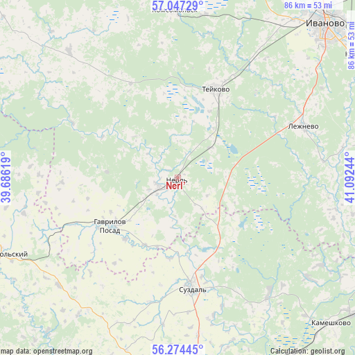
Nerl’ GPS coordinates[2]
56° 39' 46.26" North, 40° 23' 21.516" East
| Map corner | latitude | longitude |
|---|---|---|
| Upper-left | 57.04729°, | 39.68619° |
| Center: | 56.66285°, | 40.38931° |
| Lower-right: | 56.27445°, | 41.09244° |
| Map W x H: | 85.9×85.9 km | = 53.4×53.4mi |
| max Lat: | 73.50819° ⇑26% North |
| Nerl’: | 56.66285° |
| min Lat: | ⇓74% South 41.28413° |
| min Long | Nerl’ | max Long |
| -179.12198° | 40.38931° | 179.35046° |
| W 34.4%⇐ | ⇒65.6% E |
Elevation
Elevation of Nerl’ is 123 m = 404 ft, and this is 79.6 m = 261 ft below average elevation for this country.
| Max E: |
2518 m = 8261 ft | 60.6% |
| Avg. | 202.6 m = 665 ft | |
| Nerl’ | 123 m = 404 ft | |
Min E: |
-28 m = -92 ft | 39.4% |
See also: Russia elevation on elevation.city.
Geographical zone
Nerl’ is located in North temperate zone (between Tropic of Cancer and the Arctic Circle). Distance of this North polar circle is 1100.9 km =684.1 mi to North.| Distance of | km | miles | from Nerl’ |
|---|---|---|---|
| North Pole | 3706.7 | 2303.2 | to North |
| Arctic Circle | 1100.9 | 684.1 | to North |
| Tropic Cancer | 3694.4 | 2295.6 | to South |
| Equator | 6300.3 | 3914.8 | to South |


Nearby cities:
15 places around Nerl’: (largest is in red/bold)
• Gavrilov Posad
20.1 km =12.5 mi,  234°
234°
• Il’inskoye-Khovanskoye
51.1 km =31.8 mi,  312°
312°
• Ivanovo
51.3 km =31.9 mi,  43°
43°
• Kideksha
27.8 km =17.3 mi,  163°
163°
• Komsomol’sk
40.7 km =25.3 mi,  358°
358°
• Lezhnevo
33.1 km =20.6 mi,  67°
67°
• Markovo
40.1 km =24.9 mi,  9°
9°
• Novo-Talitsy
47.5 km =29.5 mi, 37°
• Novoye Leushino
17.8 km =11.1 mi,  25°
25°
• Novyye Gorki
41.5 km =25.8 mi,  80°
80°
• Petrovskiy
4.8 km =3 mi,  241°
241°
• Savino
51.3 km =31.9 mi,  98°
98°
• Suzdal’
26.9 km =16.7 mi,  172°
172°
• Teykovo
23.5 km =14.6 mi,  22°
22°
• Yur’yev-Pol’skiy
47 km =29.2 mi,  247°
247°
Sources, notices
• [Note1] Compared only with cities in Russia existing in our database
• [Src1] Map data: © OpenStreetMap contributors (CC-BY-SA)
• [Src2] Other city data from geonames.org with taken over terms of usage.
• [Src3] Geographical zone / Annual Mean Temperature by Robert A. Rohde @ Wikipedia
