Nekhayevskiy geodata
Nekhayevskiy (Volgograd Oblast) is a populated place; located in Russia in Europe/Volgograd (GMT+3) time zone. With population of 4,714 people, there are 2776 cities with bigger population in this country. Compared to other cities in Russia, 76.9% of cities are located further ↑North; 60.7% of cities are located further →East and 75% of cities have higher elevation than Nekhayevskiy. Note1


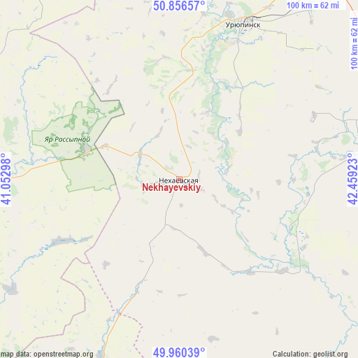
Nekhayevskiy GPS coordinates[2]
50° 24' 38.16" North, 41° 45' 21.96" East
| Map corner | latitude | longitude |
|---|---|---|
| Upper-left | 50.85657°, | 41.05298° |
| Center: | 50.4106°, | 41.7561° |
| Lower-right: | 49.96039°, | 42.45923° |
| Map W x H: | 99.6×99.6 km | = 61.9×61.9mi |
| max Lat: | 73.50819° ⇑76.9% North |
| Nekhayevskiy: | 50.4106° |
| min Lat: | ⇓23.1% South 41.28413° |
| min Long | Nekhayevskiy | max Long |
| -179.12198° | 41.7561° | 179.35046° |
| W 39.3%⇐ | ⇒60.7% E |
Elevation
Elevation of Nekhayevskiy is 88 m = 289 ft, and this is 114.6 m = 376 ft below average elevation for this country.
| Max E: |
2518 m = 8261 ft | 75% |
| Avg. | 202.6 m = 665 ft | |
| Nekhayevskiy | 88 m = 289 ft | |
Min E: |
-28 m = -92 ft | 25% |
See also: Russia elevation on elevation.city.
Geographical zone
Nekhayevskiy is located in North temperate zone (between Tropic of Cancer and the Arctic Circle). Distance of this North polar circle is 1796 km =1116 mi to North.| Distance of | km | miles | from Nekhayevskiy |
|---|---|---|---|
| North Pole | 4401.9 | 2735.2 | to North |
| Arctic Circle | 1796 | 1116 | to North |
| Tropic Cancer | 2999.2 | 1863.6 | to South |
| Equator | 5605.1 | 3482.8 | to South |


Nearby cities:
15 places around Nekhayevskiy: (largest is in red/bold)
• Alekseyevskaya
33.2 km =20.6 mi,  113°
113°
• Buturlinovka
93.1 km =57.8 mi,  299°
299°
• Kalach
51.7 km =32.1 mi,  271°
271°
• Kazanskaya
81.2 km =50.5 mi,  212°
212°
• Kumylzhenskaya
83.7 km =52 mi,  134°
134°
• Muzhich’ye
61.2 km =38 mi,  307°
307°
• Nizhniy Mamon
91.8 km =57 mi,  254°
254°
• Novoanninskiy
66.3 km =41.2 mi,  78°
78°
• Novokhopërsk
76.9 km =47.8 mi,  353°
353°
• Novonikolayevskiy
75.9 km =47.2 mi,  34°
34°
• Slashchevskaya
73.9 km =45.9 mi,  145°
145°
• Uryupinsk
47.4 km =29.5 mi,  22°
22°
• Veshenskaya
86.8 km =53.9 mi,  181°
181°
• Vorob’yëvka
62.8 km =39 mi,  294°
294°
• Yelan’-Koleno
90.4 km =56.2 mi,  335°
335°
Sources, notices
• [Note1] Compared only with cities in Russia existing in our database
• [Src1] Map data: © OpenStreetMap contributors (CC-BY-SA)
• [Src2] Other city data from geonames.org with taken over terms of usage.
• [Src3] Geographical zone / Annual Mean Temperature by Robert A. Rohde @ Wikipedia
