Muzhich’ye geodata
Muzhich’ye (Voronezj) is a populated place; located in Russia in Europe/Moscow (GMT+3) time zone. With population of 909 people, there are 4692 cities with bigger population in this country. Compared to other cities in Russia, 75.8% of cities are located further ↑North; 62.8% of cities are located further →East and 58.6% of cities have higher elevation than Muzhich’ye. Note1


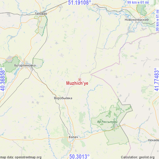
Muzhich’ye GPS coordinates[2]
50° 44' 53.88" North, 41° 4' 18.12" East
| Map corner | latitude | longitude |
|---|---|---|
| Upper-left | 51.19108°, | 40.36858° |
| Center: | 50.7483°, | 41.0717° |
| Lower-right: | 50.3013°, | 41.77483° |
| Map W x H: | 98.9×98.9 km | = 61.5×61.5mi |
| max Lat: | 73.50819° ⇑75.8% North |
| Muzhich’ye: | 50.7483° |
| min Lat: | ⇓24.2% South 41.28413° |
| min Long | Muzhich’ye | max Long |
| -179.12198° | 41.0717° | 179.35046° |
| W 37.2%⇐ | ⇒62.8% E |
Elevation
Elevation of Muzhich’ye is 127 m = 417 ft, and this is 75.6 m = 248 ft below average elevation for this country.
| Max E: |
2518 m = 8261 ft | 58.6% |
| Avg. | 202.6 m = 665 ft | |
| Muzhich’ye | 127 m = 417 ft | |
Min E: |
-28 m = -92 ft | 41.4% |
See also: Russia elevation on elevation.city.
Geographical zone
Muzhich’ye is located in North temperate zone (between Tropic of Cancer and the Arctic Circle). Distance of this North polar circle is 1758.5 km =1092.7 mi to North.| Distance of | km | miles | from Muzhich’ye |
|---|---|---|---|
| North Pole | 4364.4 | 2711.9 | to North |
| Arctic Circle | 1758.5 | 1092.7 | to North |
| Tropic Cancer | 3036.8 | 1887 | to South |
| Equator | 5642.7 | 3506.2 | to South |


Nearby cities:
15 places around Muzhich’ye: (largest is in red/bold)
• Abramovka
49.1 km =30.5 mi,  355°
355°
• Buturlinovka
33.6 km =20.9 mi,  284°
284°
• Kalach
36 km =22.4 mi,  185°
185°
• Khrenovoye
68.7 km =42.7 mi,  306°
306°
• Kozlovka
45.1 km =28 mi,  286°
286°
• Nekhayevskiy
61.2 km =38 mi,  127°
127°
• Nizhniy Kislyay
64.2 km =39.9 mi, 280°
• Novaya Chigla
67.2 km =41.8 mi,  321°
321°
• Novokhopërsk
54.8 km =34.1 mi,  45°
45°
• Talovaya
47.2 km =29.3 mi,  329°
329°
• Uryupinsk
66.5 km =41.3 mi,  84°
84°
• Vorob’yëvka
14 km =8.7 mi,  217°
217°
• Vorontsovka
52.7 km =32.7 mi,  253°
253°
• Yelan’-Koleno
46.3 km =28.8 mi,  13°
13°
• Yelan’-Kolenovskiy
46.5 km =28.9 mi, 6°
Sources, notices
• [Note1] Compared only with cities in Russia existing in our database
• [Src1] Map data: © OpenStreetMap contributors (CC-BY-SA)
• [Src2] Other city data from geonames.org with taken over terms of usage.
• [Src3] Geographical zone / Annual Mean Temperature by Robert A. Rohde @ Wikipedia
