Vorob’yëvka geodata
Vorob’yëvka (Voronezj) is a seat of a second-order administrative division; located in Russia in Europe/Moscow (GMT+3) time zone. In our database, there are 4966 cities with bigger population. Compared to other cities in Russia, 76.2% of cities are located further ↑North; 63.3% of cities are located further →East and 61.4% of cities have higher elevation than Vorob’yëvka. Note1


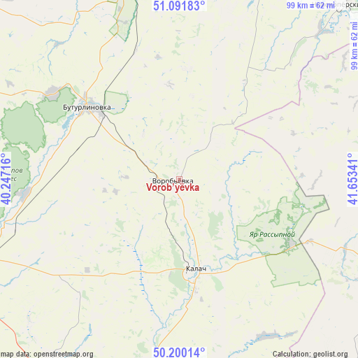
Vorob’yëvka GPS coordinates[2]
50° 38' 53.16" North, 40° 57' 1.008" East
| Map corner | latitude | longitude |
|---|---|---|
| Upper-left | 51.09183°, | 40.24716° |
| Center: | 50.6481°, | 40.95028° |
| Lower-right: | 50.20014°, | 41.65341° |
| Map W x H: | 99.1×99.1 km | = 61.6×61.6mi |
| max Lat: | 73.50819° ⇑76.2% North |
| Vorob’yëvka: | 50.6481° |
| min Lat: | ⇓23.8% South 41.28413° |
| min Long | Vorob’yëvka | max Long |
| -179.12198° | 40.95028° | 179.35046° |
| W 36.7%⇐ | ⇒63.3% E |
Elevation
Elevation of Vorob’yëvka is 121 m = 397 ft, and this is 81.6 m = 268 ft below average elevation for this country.
| Max E: |
2518 m = 8261 ft | 61.4% |
| Avg. | 202.6 m = 665 ft | |
| Vorob’yëvka | 121 m = 397 ft | |
Min E: |
-28 m = -92 ft | 38.6% |
See also: Russia elevation on elevation.city.
Geographical zone
Vorob’yëvka is located in North temperate zone (between Tropic of Cancer and the Arctic Circle). Distance of this North polar circle is 1769.6 km =1099.6 mi to North.| Distance of | km | miles | from Vorob’yëvka |
|---|---|---|---|
| North Pole | 4375.5 | 2718.8 | to North |
| Arctic Circle | 1769.6 | 1099.6 | to North |
| Tropic Cancer | 3025.6 | 1880 | to South |
| Equator | 5631.5 | 3499.3 | to South |


Nearby cities:
15 places around Vorob’yëvka: (largest is in red/bold)
• Abramovka
60.3 km =37.5 mi,  4°
4°
• Buturlinovka
31 km =19.3 mi,  309°
309°
• Kalach
25.3 km =15.7 mi,  167°
167°
• Kozlovka
42.2 km =26.2 mi,  304°
304°
• Losevo
63.9 km =39.7 mi,  272°
272°
• Muzhich’ye
14 km =8.7 mi,  37°
37°
• Nekhayevskiy
62.8 km =39 mi,  114°
114°
• Nizhniy Kislyay
59.2 km =36.8 mi,  292°
292°
• Nizhniy Mamon
59.4 km =36.9 mi,  211°
211°
• Pavlovsk
63.2 km =39.3 mi,  250°
250°
• Talovaya
54.1 km =33.6 mi,  343°
343°
• Verkhniy Mamon
67.2 km =41.8 mi,  216°
216°
• Vorontsovka
42.2 km =26.2 mi,  264°
264°
• Yelan’-Koleno
59.4 km =36.9 mi,  19°
19°
• Yelan’-Kolenovskiy
59 km =36.7 mi,  13°
13°
Sources, notices
• [Note1] Compared only with cities in Russia existing in our database
• [Src1] Map data: © OpenStreetMap contributors (CC-BY-SA)
• [Src2] Other city data from geonames.org with taken over terms of usage.
• [Src3] Geographical zone / Annual Mean Temperature by Robert A. Rohde @ Wikipedia
