Nakhabino geodata
Nakhabino (Moscow Oblast) is a populated place; located in Russia in Europe/Moscow (GMT+3) time zone. With population of 31,715 people, there are 625 cities with bigger population in this country. Compared to other cities in Russia, 64.3% of cities are located further ↓South; 84.1% of cities are located further →East and 65.4% of cities have lower elevation than Nakhabino. Note1


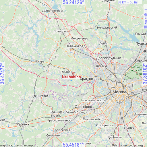
Nakhabino GPS coordinates[2]
55° 50' 54.744" North, 37° 10' 40.404" East
| Map corner | latitude | longitude |
|---|---|---|
| Upper-left | 56.24126°, | 36.47477° |
| Center: | 55.84854°, | 37.17789° |
| Lower-right: | 55.45181°, | 37.88102° |
| Map W x H: | 87.8×87.8 km | = 54.6×54.6mi |
| max Lat: | 73.50819° ⇑35.7% North |
| Nakhabino: | 55.84854° |
| min Lat: | ⇓64.3% South 41.28413° |
| min Long | Nakhabino | max Long |
| -179.12198° | 37.17789° | 179.35046° |
| W 15.9%⇐ | ⇒84.1% E |
Elevation
Elevation of Nakhabino is 183 m = 600 ft, and this is 19.6 m = 64 ft below average elevation for this country.
| Max E: |
2518 m = 8261 ft | 34.6% |
| Avg. | 202.6 m = 665 ft | |
| Nakhabino | 183 m = 600 ft | |
Min E: |
-28 m = -92 ft | 65.4% |
See also: Russia elevation on elevation.city.
Geographical zone
Nakhabino is located in North temperate zone (between Tropic of Cancer and the Arctic Circle). Distance of this North polar circle is 1191.4 km =740.3 mi to North.| Distance of | km | miles | from Nakhabino |
|---|---|---|---|
| North Pole | 3797.3 | 2359.5 | to North |
| Arctic Circle | 1191.4 | 740.3 | to North |
| Tropic Cancer | 3603.9 | 2239.4 | to South |
| Equator | 6209.8 | 3858.6 | to South |


Nearby cities:
15 places around Nakhabino: (largest is in red/bold)
• Arkhangel’skoye
10.2 km =6.3 mi,  131°
131°
• Barvikha
13.4 km =8.3 mi,  151°
151°
• Brëkhovo
9.5 km =5.9 mi,  4°
4°
• Dedovsk
4.1 km =2.5 mi,  302°
302°
• Dmitrovskoye
11 km =6.8 mi,  198°
198°
• Firsanovka
12.3 km =7.6 mi,  18°
18°
• Krasnogorsk
10 km =6.2 mi,  108°
108°
• Opalikha
5.3 km =3.3 mi,  118°
118°
• Pavlovskaya Sloboda
7 km =4.3 mi,  238°
238°
• Pavshino
11.3 km =7 mi, 108°
• Petrovo-Dal’neye
11.3 km =7 mi,  181°
181°
• Rozhdestveno
8 km =5 mi,  274°
274°
• Rublëvo
13.1 km =8.1 mi, 122°
• Skhodnya
13.4 km =8.3 mi,  34°
34°
• Snegiri
10.6 km =6.6 mi,  294°
294°
Sources, notices
• [Note1] Compared only with cities in Russia existing in our database
• [Src1] Map data: © OpenStreetMap contributors (CC-BY-SA)
• [Src2] Other city data from geonames.org with taken over terms of usage.
• [Src3] Geographical zone / Annual Mean Temperature by Robert A. Rohde @ Wikipedia
