Skhodnya geodata
Skhodnya (Moscow Oblast) is a populated place; located in Russia in Europe/Moscow (GMT+3) time zone. With population of 18,897 people, there are 913 cities with bigger population in this country. Compared to other cities in Russia, 65.8% of cities are located further ↓South; 83.4% of cities are located further →East and 69.5% of cities have lower elevation than Skhodnya. Note1


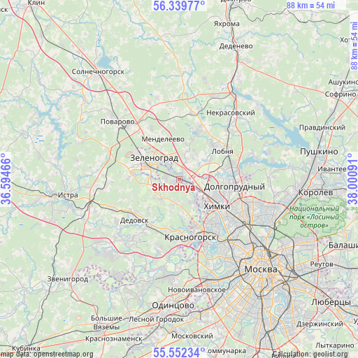
Skhodnya GPS coordinates[2]
55° 56' 53.016" North, 37° 17' 52.008" East
| Map corner | latitude | longitude |
|---|---|---|
| Upper-left | 56.33977°, | 36.59466° |
| Center: | 55.94806°, | 37.29778° |
| Lower-right: | 55.55234°, | 38.00091° |
| Map W x H: | 87.6×87.6 km | = 54.4×54.4mi |
| max Lat: | 73.50819° ⇑34.2% North |
| Skhodnya: | 55.94806° |
| min Lat: | ⇓65.8% South 41.28413° |
| min Long | Skhodnya | max Long |
| -179.12198° | 37.29778° | 179.35046° |
| W 16.6%⇐ | ⇒83.4% E |
Elevation
Elevation of Skhodnya is 196 m = 643 ft, and this is 6.6 m = 22 ft below average elevation for this country.
| Max E: |
2518 m = 8261 ft | 30.5% |
| Avg. | 202.6 m = 665 ft | |
| Skhodnya | 196 m = 643 ft | |
Min E: |
-28 m = -92 ft | 69.5% |
See also: Russia elevation on elevation.city.
Geographical zone
Skhodnya is located in North temperate zone (between Tropic of Cancer and the Arctic Circle). Distance of this North polar circle is 1180.3 km =733.4 mi to North.| Distance of | km | miles | from Skhodnya |
|---|---|---|---|
| North Pole | 3786.2 | 2352.6 | to North |
| Arctic Circle | 1180.3 | 733.4 | to North |
| Tropic Cancer | 3614.9 | 2246.2 | to South |
| Equator | 6220.8 | 3865.4 | to South |


Nearby cities:
15 places around Skhodnya: (largest is in red/bold)
• Alabushevo
11.9 km =7.4 mi,  309°
309°
• Andreyevka
10.7 km =6.6 mi,  289°
289°
• Brëkhovo
6.9 km =4.3 mi,  256°
256°
• Chashnikovo
12.5 km =7.8 mi,  319°
319°
• Dolgoprudnyy
12.7 km =7.9 mi,  89°
89°
• Firsanovka
3.6 km =2.2 mi,  279°
279°
• Khimki
10 km =6.2 mi,  124°
124°
• Lobnya
13.4 km =8.3 mi,  59°
59°
• Mendeleyevo
10.7 km =6.6 mi,  331°
331°
• Nakhabino
13.4 km =8.3 mi,  214°
214°
• Novopodrezkovo
3 km =1.9 mi,  107°
107°
• Opalikha
13.9 km =8.6 mi,  191°
191°
• Rzhavki
6.5 km =4 mi, 332°
• Sheremet’yevskiy
12.6 km =7.8 mi,  75°
75°
• Zelenograd
8.2 km =5.1 mi,  297°
297°
Sources, notices
• [Note1] Compared only with cities in Russia existing in our database
• [Src1] Map data: © OpenStreetMap contributors (CC-BY-SA)
• [Src2] Other city data from geonames.org with taken over terms of usage.
• [Src3] Geographical zone / Annual Mean Temperature by Robert A. Rohde @ Wikipedia
