Vladikavkaz geodata
Vladikavkaz (North Ossetia) is a seat of a first-order administrative division; located in Russia in Europe/Moscow (GMT+3) time zone. With population of 317,370 people, there are 60 cities with bigger population in this country. Compared to other cities in Russia, 97.5% of cities are located further ↑North; 51% of cities are located further →East and 95.6% of cities have lower elevation than Vladikavkaz. Note1


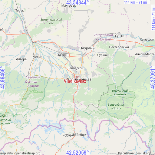
Vladikavkaz GPS coordinates[2]
43° 2' 12.012" North, 44° 40' 4.008" East
| Map corner | latitude | longitude |
|---|---|---|
| Upper-left | 43.54844°, | 43.96466° |
| Center: | 43.03667°, | 44.66778° |
| Lower-right: | 42.52059°, | 45.37091° |
| Map W x H: | 114.3×114.3 km | = 71×71mi |
| max Lat: | 73.50819° ⇑97.5% North |
| Vladikavkaz: | 43.03667° |
| min Lat: | ⇓2.5% South 41.28413° |
| min Long | Vladikavkaz | max Long |
| -179.12198° | 44.66778° | 179.35046° |
| W 49%⇐ | ⇒51% E |
Elevation
Elevation of Vladikavkaz is 671 m = 2201 ft, and this is 468.4 m = 1537 ft above average elevation for this country.
| Max E: |
2518 m = 8261 ft | 4.4% |
| Vladikavkaz | 671 m 2201 ft | |
| Avg. | 202.6 m = 665 ft | |
Min E: |
-28 m = -92 ft | 95.6% |
See also: Vladikavkaz elevation on elevation.city.
Geographical zone
Vladikavkaz is located in North temperate zone (between Tropic of Cancer and the Arctic Circle). Distance of this Northern Tropic circle is 2179.3 km =1354.2 mi to South.| Distance of | km | miles | from Vladikavkaz |
|---|---|---|---|
| North Pole | 5221.8 | 3244.7 | to North |
| Arctic Circle | 2615.9 | 1625.4 | to North |
| Tropic Cancer | 2179.3 | 1354.2 | to South |
| Equator | 4785.2 | 2973.4 | to South |


Nearby cities:
15 places around Vladikavkaz: (largest is in red/bold)
• Ali-Yurt
19.1 km =11.9 mi,  51°
51°
• Arkhonskaya
15 km =9.3 mi,  302°
302°
• Beslan
20 km =12.4 mi,  329°
329°
• Chermen
13.3 km =8.3 mi,  15°
15°
• Dachnoye
7.7 km =4.8 mi, 45°
• Ekazhevo
23.2 km =14.4 mi,  32°
32°
• Gizel’
7.9 km =4.9 mi,  272°
272°
• Kambileyevskoye
8.3 km =5.2 mi,  55°
55°
• Kantyshevo
21.5 km =13.4 mi,  352°
352°
• Magas
22.4 km =13.9 mi, 22°
• Mikhaylovskoye
7.6 km =4.7 mi,  337°
337°
• Nazran’
22.7 km =14.1 mi, 22°
• Nogir
5.6 km =3.5 mi, 333°
• Sunzha
12.8 km =8 mi,  79°
79°
• Tarskoye
11.8 km =7.3 mi,  131°
131°
In other languages:
- In Spanish: Vladicáucaso
- In German: Wladikawkas
- In Russian: Владикавказ
- In Chinese: 弗拉季高加索
Sources, notices
• [Note1] Compared only with cities in Russia existing in our database
• [Src1] Map data: © OpenStreetMap contributors (CC-BY-SA)
• [Src2] Other city data from geonames.org with taken over terms of usage.
• [Src3] Geographical zone / Annual Mean Temperature by Robert A. Rohde @ Wikipedia
