Mendeleyevo geodata
Mendeleyevo (Perm) is a populated place; located in Russia in Asia/Yekaterinburg (GMT+5) time zone. With population of 3,245 people, there are 3570 cities with bigger population in this country. Compared to other cities in Russia, 83.4% of cities are located further ↓South; 66.6% of cities are located further ←West and 74.5% of cities have lower elevation than Mendeleyevo. Note1


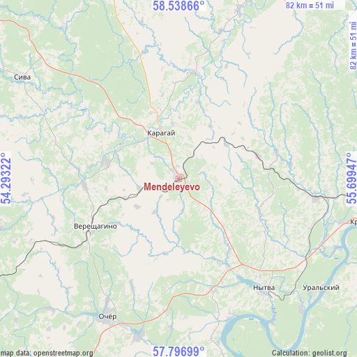
Mendeleyevo GPS coordinates[2]
58° 10' 11.136" North, 54° 59' 46.824" East
| Map corner | latitude | longitude |
|---|---|---|
| Upper-left | 58.53866°, | 54.29322° |
| Center: | 58.16976°, | 54.99634° |
| Lower-right: | 57.79699°, | 55.69947° |
| Map W x H: | 82.5×82.5 km | = 51.3×51.3mi |
| max Lat: | 73.50819° ⇑16.6% North |
| Mendeleyevo: | 58.16976° |
| min Lat: | ⇓83.4% South 41.28413° |
| min Long | Mendeleyevo | max Long |
| -179.12198° | 54.99634° | 179.35046° |
| W 66.6%⇐ | ⇒33.4% E |
Elevation
Elevation of Mendeleyevo is 214 m = 702 ft, and this is 11.4 m = 37 ft above average elevation for this country.
| Max E: |
2518 m = 8261 ft | 25.5% |
| Mendeleyevo | 214 m 702 ft | |
| Avg. | 202.6 m = 665 ft | |
Min E: |
-28 m = -92 ft | 74.5% |
See also: Russia elevation on elevation.city.
Geographical zone
Mendeleyevo is located in North temperate zone (between Tropic of Cancer and the Arctic Circle). Distance of this North polar circle is 933.3 km =579.9 mi to North.| Distance of | km | miles | from Mendeleyevo |
|---|---|---|---|
| North Pole | 3539.2 | 2199.2 | to North |
| Arctic Circle | 933.3 | 579.9 | to North |
| Tropic Cancer | 3862 | 2399.7 | to South |
| Equator | 6467.9 | 4019 | to South |


Nearby cities:
15 places around Mendeleyevo: (largest is in red/bold)
• Chaykovskaya
31.9 km =19.8 mi,  98°
98°
• Karagay
11.3 km =7 mi,  342°
342°
• Krasnokamsk
45.7 km =28.4 mi, 102°
• Kultayevo
63.3 km =39.3 mi,  118°
118°
• Nytva
32.2 km =20 mi,  141°
141°
• Ochër
35.1 km =21.8 mi,  207°
207°
• Okhansk
55.1 km =34.2 mi,  155°
155°
• Overyata
52 km =32.3 mi, 100°
• Pavlovskiy
37.5 km =23.3 mi,  193°
193°
• Siva
43.1 km =26.8 mi,  303°
303°
• Sokol
68 km =42.3 mi,  114°
114°
• Ust’-Kachka
43.8 km =27.2 mi, 114°
• Vereshchagino
22.4 km =13.9 mi,  243°
243°
• Yugo-Kamskiy
62.7 km =39 mi,  145°
145°
• Zyukayka
17.3 km =10.7 mi,  282°
282°
Sources, notices
• [Note1] Compared only with cities in Russia existing in our database
• [Src1] Map data: © OpenStreetMap contributors (CC-BY-SA)
• [Src2] Other city data from geonames.org with taken over terms of usage.
• [Src3] Geographical zone / Annual Mean Temperature by Robert A. Rohde @ Wikipedia
