Melekhovo geodata
Melekhovo (Vladimir) is a populated place; located in Russia in Europe/Moscow (GMT+3) time zone. With population of 6,922 people, there are 2024 cities with bigger population in this country. Compared to other cities in Russia, 70.3% of cities are located further ↓South; 62% of cities are located further →East and 72.2% of cities have higher elevation than Melekhovo. Note1


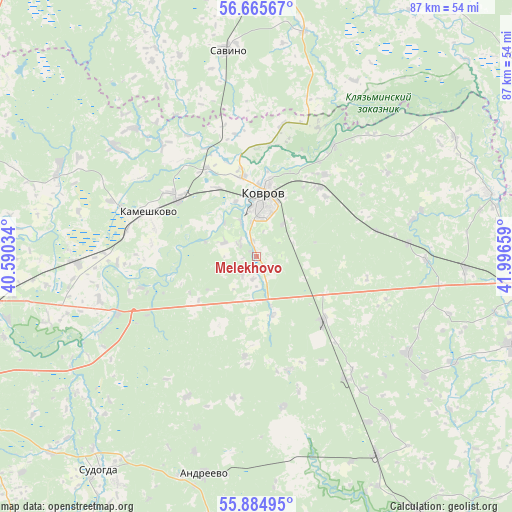
Melekhovo GPS coordinates[2]
56° 16' 38.28" North, 41° 17' 36.456" East
| Map corner | latitude | longitude |
|---|---|---|
| Upper-left | 56.66567°, | 40.59034° |
| Center: | 56.2773°, | 41.29346° |
| Lower-right: | 55.88495°, | 41.99659° |
| Map W x H: | 86.8×86.8 km | = 53.9×53.9mi |
| max Lat: | 73.50819° ⇑29.7% North |
| Melekhovo: | 56.2773° |
| min Lat: | ⇓70.3% South 41.28413° |
| min Long | Melekhovo | max Long |
| -179.12198° | 41.29346° | 179.35046° |
| W 38%⇐ | ⇒62% E |
Elevation
Elevation of Melekhovo is 97 m = 318 ft, and this is 105.6 m = 346 ft below average elevation for this country.
| Max E: |
2518 m = 8261 ft | 72.2% |
| Avg. | 202.6 m = 665 ft | |
| Melekhovo | 97 m = 318 ft | |
Min E: |
-28 m = -92 ft | 27.8% |
See also: Russia elevation on elevation.city.
Geographical zone
Melekhovo is located in North temperate zone (between Tropic of Cancer and the Arctic Circle). Distance of this North polar circle is 1143.7 km =710.7 mi to North.| Distance of | km | miles | from Melekhovo |
|---|---|---|---|
| North Pole | 3749.6 | 2329.9 | to North |
| Arctic Circle | 1143.7 | 710.7 | to North |
| Tropic Cancer | 3651.5 | 2268.9 | to South |
| Equator | 6257.4 | 3888.2 | to South |


Nearby cities:
15 places around Melekhovo: (largest is in red/bold)
• Andreyevo
37.8 km =23.5 mi,  193°
193°
• Arkhipovka
42.9 km =26.7 mi,  356°
356°
• Kameshkovo
19.4 km =12.1 mi,  295°
295°
• Kovrov
9 km =5.6 mi,  10°
10°
• Krasnyy Bogatyr’
30.9 km =19.2 mi,  199°
199°
• Krasnyy Mayak
25.8 km =16 mi,  169°
169°
• Krasnyy Oktyabr’
20.1 km =12.5 mi,  163°
163°
• Mstera
40.2 km =25 mi,  73°
73°
• Muromtsevo
45.3 km =28.1 mi,  211°
211°
• Nikologory
45.8 km =28.5 mi,  109°
109°
• Novki
16 km =9.9 mi,  307°
307°
• Orgtrud
43.2 km =26.8 mi,  255°
255°
• Savino
35.4 km =22 mi,  352°
352°
• Stepantsevo
30.1 km =18.7 mi,  122°
122°
• Sudogda
44.8 km =27.8 mi,  216°
216°
Sources, notices
• [Note1] Compared only with cities in Russia existing in our database
• [Src1] Map data: © OpenStreetMap contributors (CC-BY-SA)
• [Src2] Other city data from geonames.org with taken over terms of usage.
• [Src3] Geographical zone / Annual Mean Temperature by Robert A. Rohde @ Wikipedia
