Malgobek geodata
Malgobek (Ingushetiya Republic) is a populated place; located in Russia in Europe/Moscow (GMT+3) time zone. With population of 43,400 people, there are 483 cities with bigger population in this country. Compared to other cities in Russia, 94% of cities are located further ↑North; 51.3% of cities are located further →East and 86.9% of cities have lower elevation than Malgobek. Note1


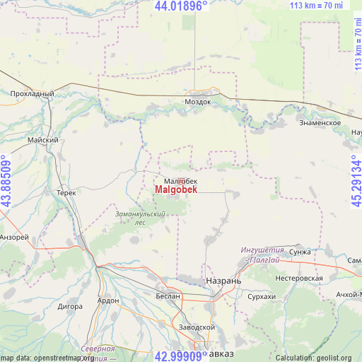
Malgobek GPS coordinates[2]
43° 30' 40.248" North, 44° 35' 17.556" East
| Map corner | latitude | longitude |
|---|---|---|
| Upper-left | 44.01896°, | 43.88509° |
| Center: | 43.51118°, | 44.58821° |
| Lower-right: | 42.99909°, | 45.29134° |
| Map W x H: | 113.4×113.4 km | = 70.5×70.5mi |
| max Lat: | 73.50819° ⇑94% North |
| Malgobek: | 43.51118° |
| min Lat: | ⇓6% South 41.28413° |
| min Long | Malgobek | max Long |
| -179.12198° | 44.58821° | 179.35046° |
| W 48.7%⇐ | ⇒51.3% E |
Elevation
Elevation of Malgobek is 368 m = 1207 ft, and this is 165.4 m = 543 ft above average elevation for this country.
| Max E: |
2518 m = 8261 ft | 13.1% |
| Malgobek | 368 m 1207 ft | |
| Avg. | 202.6 m = 665 ft | |
Min E: |
-28 m = -92 ft | 86.9% |
See also: Malgobek elevation on elevation.city.
Geographical zone
Malgobek is located in North temperate zone (between Tropic of Cancer and the Arctic Circle). Distance of this Northern Tropic circle is 2232.1 km =1387 mi to South.| Distance of | km | miles | from Malgobek |
|---|---|---|---|
| North Pole | 5169.1 | 3211.9 | to North |
| Arctic Circle | 2563.2 | 1592.7 | to North |
| Tropic Cancer | 2232.1 | 1387 | to South |
| Equator | 4838 | 3006.2 | to South |


Nearby cities:
15 places around Malgobek: (largest is in red/bold)
• Alkhan-Churt
23.9 km =14.9 mi,  137°
137°
• Dalakovo
30.4 km =18.9 mi,  179°
179°
• Khumalag
31.5 km =19.6 mi,  196°
196°
• Kizlyar
21.4 km =13.3 mi,  1°
1°
• Mozdok
26.3 km =16.3 mi,  11°
11°
• Nizhniye Achaluki
18.3 km =11.4 mi,  131°
131°
• Nogamerzin-Yurt
28.9 km =18 mi,  56°
56°
• Pavlodol’skaya
24.8 km =15.4 mi,  339°
339°
• Psedakh
5.1 km =3.2 mi, 197°
• Sagopshi
2.9 km =1.8 mi, 176°
• Staryy Malgobek
3.7 km =2.3 mi, 9°
• Terskaya
26.1 km =16.2 mi,  24°
24°
• Troitskoye
29 km =18 mi, 15°
• Verkhniye Achaluki
20.3 km =12.6 mi,  154°
154°
• Voznesenskaya
13.2 km =8.2 mi,  74°
74°
Sources, notices
• [Note1] Compared only with cities in Russia existing in our database
• [Src1] Map data: © OpenStreetMap contributors (CC-BY-SA)
• [Src2] Other city data from geonames.org with taken over terms of usage.
• [Src3] Geographical zone / Annual Mean Temperature by Robert A. Rohde @ Wikipedia
