Maksatikha geodata
Maksatikha (Tver’ Oblast) is a populated place; located in Russia in Europe/Moscow (GMT+3) time zone. With population of 9,441 people, there are 1598 cities with bigger population in this country. Compared to other cities in Russia, 81.6% of cities are located further ↓South; 87.7% of cities are located further →East and 51.6% of cities have higher elevation than Maksatikha. Note1


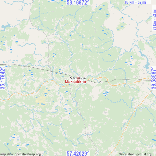
Maksatikha GPS coordinates[2]
57° 47' 49.02" North, 35° 52' 57.144" East
| Map corner | latitude | longitude |
|---|---|---|
| Upper-left | 58.16972°, | 35.17942° |
| Center: | 57.79695°, | 35.88254° |
| Lower-right: | 57.42029°, | 36.58567° |
| Map W x H: | 83.3×83.3 km | = 51.8×51.8mi |
| max Lat: | 73.50819° ⇑18.4% North |
| Maksatikha: | 57.79695° |
| min Lat: | ⇓81.6% South 41.28413° |
| min Long | Maksatikha | max Long |
| -179.12198° | 35.88254° | 179.35046° |
| W 12.3%⇐ | ⇒87.7% E |
Elevation
Elevation of Maksatikha is 141 m = 463 ft, and this is 61.6 m = 202 ft below average elevation for this country.
| Max E: |
2518 m = 8261 ft | 51.6% |
| Avg. | 202.6 m = 665 ft | |
| Maksatikha | 141 m = 463 ft | |
Min E: |
-28 m = -92 ft | 48.4% |
See also: Russia elevation on elevation.city.
Geographical zone
Maksatikha is located in North temperate zone (between Tropic of Cancer and the Arctic Circle). Distance of this North polar circle is 974.8 km =605.7 mi to North.| Distance of | km | miles | from Maksatikha |
|---|---|---|---|
| North Pole | 3580.6 | 2224.9 | to North |
| Arctic Circle | 974.8 | 605.7 | to North |
| Tropic Cancer | 3820.5 | 2373.9 | to South |
| Equator | 6426.4 | 3993.2 | to South |


Nearby cities:
15 places around Maksatikha: (largest is in red/bold)
• Bezhetsk
48.3 km =30 mi,  91°
91°
• Kalashnikovo
69.3 km =43.1 mi,  214°
214°
• Kesova Gora
87.1 km =54.1 mi,  105°
105°
• Krasnyy Kholm
78.7 km =48.9 mi,  68°
68°
• Lesnoye
58.3 km =36.2 mi,  338°
338°
• Likhoslavl’
78.5 km =48.8 mi,  198°
198°
• Molokovo
66.2 km =41.1 mi,  51°
51°
• Rameshki
51.3 km =31.9 mi,  169°
169°
• Sandovo
80 km =49.7 mi,  22°
22°
• Sonkovo
75.6 km =47 mi, 91°
• Spirovo
68.4 km =42.5 mi,  232°
232°
• Udomlya
53.5 km =33.2 mi,  279°
279°
• Vasil’yevskiy Mokh
87.2 km =54.2 mi,  178°
178°
• Vydropuzhsk
78.4 km =48.7 mi, 232°
• Vyshniy Volochëk
81.6 km =50.7 mi,  253°
253°
Sources, notices
• [Note1] Compared only with cities in Russia existing in our database
• [Src1] Map data: © OpenStreetMap contributors (CC-BY-SA)
• [Src2] Other city data from geonames.org with taken over terms of usage.
• [Src3] Geographical zone / Annual Mean Temperature by Robert A. Rohde @ Wikipedia
