Lytkarino geodata
Lytkarino (Moscow Oblast) is a populated place; located in Russia in Europe/Moscow (GMT+3) time zone. With population of 50,619 people, there are 410 cities with bigger population in this country. Compared to other cities in Russia, 59.3% of cities are located further ↓South; 78% of cities are located further →East and 58.2% of cities have lower elevation than Lytkarino. Note1


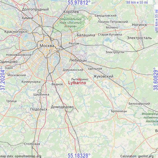
Lytkarino GPS coordinates[2]
55° 34' 57.756" North, 37° 54' 18.576" East
| Map corner | latitude | longitude |
|---|---|---|
| Upper-left | 55.97812°, | 37.20204° |
| Center: | 55.58271°, | 37.90516° |
| Lower-right: | 55.18328°, | 38.60829° |
| Map W x H: | 88.4×88.4 km | = 54.9×54.9mi |
| max Lat: | 73.50819° ⇑40.7% North |
| Lytkarino: | 55.58271° |
| min Lat: | ⇓59.3% South 41.28413° |
| min Long | Lytkarino | max Long |
| -179.12198° | 37.90516° | 179.35046° |
| W 22%⇐ | ⇒78% E |
Elevation
Elevation of Lytkarino is 164 m = 538 ft, and this is 38.6 m = 127 ft below average elevation for this country.
| Max E: |
2518 m = 8261 ft | 41.8% |
| Avg. | 202.6 m = 665 ft | |
| Lytkarino | 164 m = 538 ft | |
Min E: |
-28 m = -92 ft | 58.2% |
See also: Lytkarino elevation on elevation.city.
Geographical zone
Lytkarino is located in North temperate zone (between Tropic of Cancer and the Arctic Circle). Distance of this North polar circle is 1221 km =758.7 mi to North.| Distance of | km | miles | from Lytkarino |
|---|---|---|---|
| North Pole | 3826.8 | 2377.9 | to North |
| Arctic Circle | 1221 | 758.7 | to North |
| Tropic Cancer | 3574.3 | 2221 | to South |
| Equator | 6180.2 | 3840.2 | to South |


Nearby cities:
15 places around Lytkarino: (largest is in red/bold)
• Alekseyevka
8.4 km =5.2 mi,  308°
308°
• Andreyevskoye
3.4 km =2.1 mi,  157°
157°
• Dzerzhinskiy
6 km =3.7 mi,  329°
329°
• Dzerzhinsky
5.8 km =3.6 mi, 329°
• Kapotnya
9.4 km =5.8 mi, 311°
• Kotel’niki
7 km =4.3 mi, 326°
• Kraskovo
9.1 km =5.7 mi,  34°
34°
• Molokovo
3.4 km =2.1 mi,  227°
227°
• Oktyabr’skiy
5.3 km =3.3 mi,  58°
58°
• Ostrovtsy
6.3 km =3.9 mi,  85°
85°
• Petrovskaya
8.5 km =5.3 mi,  244°
244°
• Tomilino
8.6 km =5.3 mi,  17°
17°
• Udel’naya
7.8 km =4.8 mi,  52°
52°
• Vereya
9.1 km =5.7 mi,  67°
67°
• Volodarskogo
9.1 km =5.7 mi,  165°
165°
Sources, notices
• [Note1] Compared only with cities in Russia existing in our database
• [Src1] Map data: © OpenStreetMap contributors (CC-BY-SA)
• [Src2] Other city data from geonames.org with taken over terms of usage.
• [Src3] Geographical zone / Annual Mean Temperature by Robert A. Rohde @ Wikipedia
