Dzerzhinsky geodata
Dzerzhinsky (Moscow Oblast) is a populated place; located in Russia in Europe/Moscow (GMT+3) time zone. With population of 47,163 people, there are 449 cities with bigger population in this country. Compared to other cities in Russia, 60.3% of cities are located further ↓South; 78.3% of cities are located further →East and 50.7% of cities have higher elevation than Dzerzhinsky. Note1


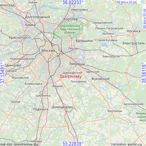
Dzerzhinsky GPS coordinates[2]
55° 37' 38.532" North, 37° 51' 28.908" East
| Map corner | latitude | longitude |
|---|---|---|
| Upper-left | 56.02233°, | 37.15491° |
| Center: | 55.62737°, | 37.85803° |
| Lower-right: | 55.22839°, | 38.56116° |
| Map W x H: | 88.3×88.3 km | = 54.9×54.9mi |
| max Lat: | 73.50819° ⇑39.7% North |
| Dzerzhinsky: | 55.62737° |
| min Lat: | ⇓60.3% South 41.28413° |
| min Long | Dzerzhinsky | max Long |
| -179.12198° | 37.85803° | 179.35046° |
| W 21.7%⇐ | ⇒78.3% E |
Elevation
Elevation of Dzerzhinsky is 143 m = 469 ft, and this is 59.6 m = 196 ft below average elevation for this country.
| Max E: |
2518 m = 8261 ft | 50.7% |
| Avg. | 202.6 m = 665 ft | |
| Dzerzhinsky | 143 m = 469 ft | |
Min E: |
-28 m = -92 ft | 49.3% |
See also: Dzerzhinsky elevation on elevation.city.
Geographical zone
Dzerzhinsky is located in North temperate zone (between Tropic of Cancer and the Arctic Circle). Distance of this North polar circle is 1216 km =755.6 mi to North.| Distance of | km | miles | from Dzerzhinsky |
|---|---|---|---|
| North Pole | 3821.9 | 2374.8 | to North |
| Arctic Circle | 1216 | 755.6 | to North |
| Tropic Cancer | 3579.3 | 2224.1 | to South |
| Equator | 6185.2 | 3843.3 | to South |


Nearby cities:
15 places around Dzerzhinsky: (largest is in red/bold)
• Alekseyevka
3.7 km =2.3 mi,  274°
274°
• Brateyevo
6 km =3.7 mi,  280°
280°
• Dzerzhinskiy
0.2 km =0.1 mi,  337°
337°
• Kapotnya
4.2 km =2.6 mi,  286°
286°
• Kotel’niki
1.2 km =0.7 mi,  316°
316°
• Lytkarino
5.8 km =3.6 mi,  149°
149°
• Lyubertsy
6 km =3.7 mi,  21°
21°
• Molokovo
7.3 km =4.5 mi,  176°
176°
• Nekrasovka
8.1 km =5 mi, 24°
• Oktyabr’skiy
7.8 km =4.8 mi,  105°
105°
• Orekhovo-Borisovo Yuzhnoye
7.9 km =4.9 mi, 274°
• Razvilka
8.3 km =5.2 mi,  241°
241°
• Tomilino
6.4 km =4 mi,  60°
60°
• Zhulebino
8.1 km =5 mi,  356°
356°
• Zyablikovo
5.9 km =3.7 mi,  258°
258°
Sources, notices
• [Note1] Compared only with cities in Russia existing in our database
• [Src1] Map data: © OpenStreetMap contributors (CC-BY-SA)
• [Src2] Other city data from geonames.org with taken over terms of usage.
• [Src3] Geographical zone / Annual Mean Temperature by Robert A. Rohde @ Wikipedia
