Lunino geodata
Lunino (Penza) is a populated place; located in Russia in Europe/Moscow (GMT+3) time zone. With population of 8,214 people, there are 1765 cities with bigger population in this country. Compared to other cities in Russia, 58.1% of cities are located further ↑North; 50.8% of cities are located further ←West and 51.1% of cities have lower elevation than Lunino. Note1


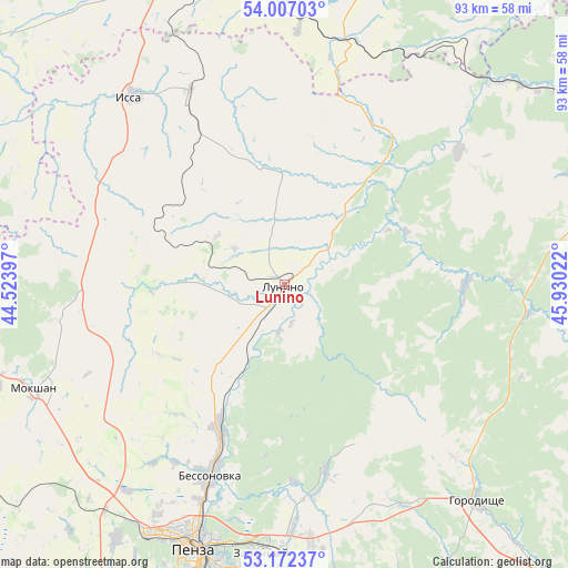
Lunino GPS coordinates[2]
53° 35' 30.336" North, 45° 13' 37.524" East
| Map corner | latitude | longitude |
|---|---|---|
| Upper-left | 54.00703°, | 44.52397° |
| Center: | 53.59176°, | 45.22709° |
| Lower-right: | 53.17237°, | 45.93022° |
| Map W x H: | 92.8×92.8 km | = 57.7×57.7mi |
| max Lat: | 73.50819° ⇑58.1% North |
| Lunino: | 53.59176° |
| min Lat: | ⇓41.9% South 41.28413° |
| min Long | Lunino | max Long |
| -179.12198° | 45.22709° | 179.35046° |
| W 50.8%⇐ | ⇒49.2% E |
Elevation
Elevation of Lunino is 147 m = 482 ft, and this is 55.6 m = 182 ft below average elevation for this country.
| Max E: |
2518 m = 8261 ft | 48.9% |
| Avg. | 202.6 m = 665 ft | |
| Lunino | 147 m = 482 ft | |
Min E: |
-28 m = -92 ft | 51.1% |
See also: Russia elevation on elevation.city.
Geographical zone
Lunino is located in North temperate zone (between Tropic of Cancer and the Arctic Circle). Distance of this North polar circle is 1442.3 km =896.2 mi to North.| Distance of | km | miles | from Lunino |
|---|---|---|---|
| North Pole | 4048.2 | 2515.4 | to North |
| Arctic Circle | 1442.3 | 896.2 | to North |
| Tropic Cancer | 3352.9 | 2083.4 | to South |
| Equator | 5958.8 | 3702.6 | to South |


Nearby cities:
15 places around Lunino: (largest is in red/bold)
• Bessonovka
33.7 km =20.9 mi,  201°
201°
• Bogoslovka
51.1 km =31.8 mi,  213°
213°
• Chemodanovka
40.1 km =24.9 mi,  178°
178°
• Gorodishche
47 km =29.2 mi,  138°
138°
• Grabovo
25.1 km =15.6 mi, 205°
• Issa
39.4 km =24.5 mi,  321°
321°
• Kochkurovo
50.9 km =31.6 mi,  14°
14°
• Mokshan
44.1 km =27.4 mi,  246°
246°
• Penza
45.9 km =28.5 mi, 198°
• Ruzayevka
55.5 km =34.5 mi,  340°
340°
• Sura
47.2 km =29.3 mi,  45°
45°
• Tatarskaya Pishlya
56.4 km =35 mi, 337°
• Zarechnyy
43.2 km =26.8 mi, 183°
• Zasechnoye
54.5 km =33.9 mi,  190°
190°
• Zykovo
53.8 km =33.4 mi,  350°
350°
Sources, notices
• [Note1] Compared only with cities in Russia existing in our database
• [Src1] Map data: © OpenStreetMap contributors (CC-BY-SA)
• [Src2] Other city data from geonames.org with taken over terms of usage.
• [Src3] Geographical zone / Annual Mean Temperature by Robert A. Rohde @ Wikipedia
