Kochkurovo geodata
Kochkurovo (Mordoviya Republic) is a populated place; located in Russia in Europe/Moscow (GMT+3) time zone. With population of 3,185 people, there are 3621 cities with bigger population in this country. Compared to other cities in Russia, 54.9% of cities are located further ↑North; 51.3% of cities are located further ←West and 64.6% of cities have lower elevation than Kochkurovo. Note1


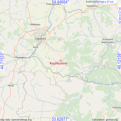
Kochkurovo GPS coordinates[2]
54° 2' 8.736" North, 45° 25' 6.42" East
| Map corner | latitude | longitude |
|---|---|---|
| Upper-left | 54.44664°, | 44.71533° |
| Center: | 54.03576°, | 45.41845° |
| Lower-right: | 53.62077°, | 46.12158° |
| Map W x H: | 91.8×91.8 km | = 57×57mi |
| max Lat: | 73.50819° ⇑54.9% North |
| Kochkurovo: | 54.03576° |
| min Lat: | ⇓45.1% South 41.28413° |
| min Long | Kochkurovo | max Long |
| -179.12198° | 45.41845° | 179.35046° |
| W 51.3%⇐ | ⇒48.7% E |
Elevation
Elevation of Kochkurovo is 181 m = 594 ft, and this is 21.6 m = 71 ft below average elevation for this country.
| Max E: |
2518 m = 8261 ft | 35.4% |
| Avg. | 202.6 m = 665 ft | |
| Kochkurovo | 181 m = 594 ft | |
Min E: |
-28 m = -92 ft | 64.6% |
See also: Russia elevation on elevation.city.
Geographical zone
Kochkurovo is located in North temperate zone (between Tropic of Cancer and the Arctic Circle). Distance of this North polar circle is 1393 km =865.6 mi to North.| Distance of | km | miles | from Kochkurovo |
|---|---|---|---|
| North Pole | 3998.8 | 2484.7 | to North |
| Arctic Circle | 1393 | 865.6 | to North |
| Tropic Cancer | 3402.3 | 2114.1 | to South |
| Equator | 6008.2 | 3733.3 | to South |


Nearby cities:
15 places around Kochkurovo: (largest is in red/bold)
• Atemar
16.2 km =10.1 mi,  357°
357°
• Chamzinka
47.1 km =29.3 mi,  30°
30°
• Issa
41 km =25.5 mi,  243°
243°
• Lukhovka
16.4 km =10.2 mi,  320°
320°
• Lunino
50.9 km =31.6 mi,  194°
194°
• Lyambir’
33.4 km =20.8 mi,  325°
325°
• Nikolayevka
21.6 km =13.4 mi,  304°
304°
• Nikol’sk
55.4 km =34.4 mi,  129°
129°
• Romodanovo
43.9 km =27.3 mi,  352°
352°
• Ruzayevka
30.7 km =19.1 mi,  275°
275°
• Saransk
22.9 km =14.2 mi, 316°
• Staraya Terizmorga
62.9 km =39.1 mi,  293°
293°
• Sura
26.8 km =16.7 mi, 127°
• Tatarskaya Pishlya
34 km =21.1 mi,  274°
274°
• Zykovo
22 km =13.7 mi, 279°
Sources, notices
• [Note1] Compared only with cities in Russia existing in our database
• [Src1] Map data: © OpenStreetMap contributors (CC-BY-SA)
• [Src2] Other city data from geonames.org with taken over terms of usage.
• [Src3] Geographical zone / Annual Mean Temperature by Robert A. Rohde @ Wikipedia
