Livenka geodata
Livenka (Belgorod Oblast) is a populated place; located in Russia in Europe/Moscow (GMT+3) time zone. With population of 4,154 people, there are 3029 cities with bigger population in this country. Compared to other cities in Russia, 76.8% of cities are located further ↑North; 75.4% of cities are located further →East and 59.2% of cities have higher elevation than Livenka. Note1


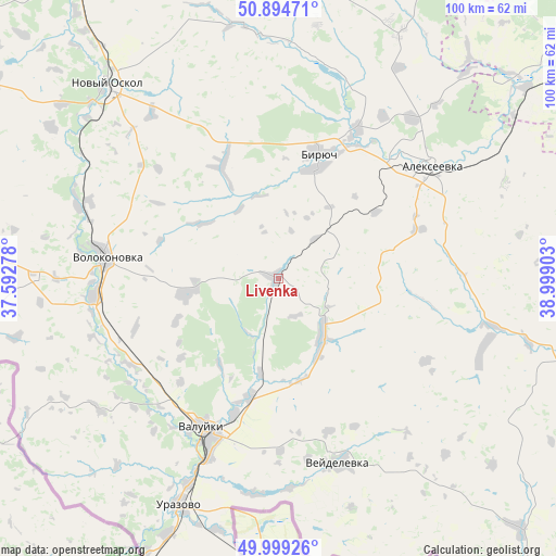
Livenka GPS coordinates[2]
50° 26' 56.76" North, 38° 17' 45.24" East
| Map corner | latitude | longitude |
|---|---|---|
| Upper-left | 50.89471°, | 37.59278° |
| Center: | 50.4491°, | 38.2959° |
| Lower-right: | 49.99926°, | 38.99903° |
| Map W x H: | 99.6×99.6 km | = 61.9×61.9mi |
| max Lat: | 73.50819° ⇑76.8% North |
| Livenka: | 50.4491° |
| min Lat: | ⇓23.2% South 41.28413° |
| min Long | Livenka | max Long |
| -179.12198° | 38.2959° | 179.35046° |
| W 24.6%⇐ | ⇒75.4% E |
Elevation
Elevation of Livenka is 126 m = 413 ft, and this is 76.6 m = 251 ft below average elevation for this country.
| Max E: |
2518 m = 8261 ft | 59.2% |
| Avg. | 202.6 m = 665 ft | |
| Livenka | 126 m = 413 ft | |
Min E: |
-28 m = -92 ft | 40.8% |
See also: Russia elevation on elevation.city.
Geographical zone
Livenka is located in North temperate zone (between Tropic of Cancer and the Arctic Circle). Distance of this North polar circle is 1791.8 km =1113.4 mi to North.| Distance of | km | miles | from Livenka |
|---|---|---|---|
| North Pole | 4397.6 | 2732.5 | to North |
| Arctic Circle | 1791.8 | 1113.4 | to North |
| Tropic Cancer | 3003.5 | 1866.3 | to South |
| Equator | 5609.4 | 3485.5 | to South |


Nearby cities:
15 places around Livenka: (largest is in red/bold)
• Alekseyevka
34.4 km =21.4 mi,  54°
54°
• Chernyanka
64.6 km =40.1 mi,  327°
327°
• Ilovka
37.3 km =23.2 mi,  40°
40°
• Krasnogvardeyskoye
23.5 km =14.6 mi,  18°
18°
• Krasnoye
60 km =37.3 mi,  26°
26°
• Novyy Oskol
46.4 km =28.8 mi,  318°
318°
• Ol’khovatka
72.7 km =45.2 mi,  104°
104°
• Ostrogozhsk
71.9 km =44.7 mi, 49°
• Pyatnitskoye
33.3 km =20.7 mi,  265°
265°
• Urazovo
44.5 km =27.7 mi,  204°
204°
• Valuyki
30.4 km =18.9 mi,  206°
206°
• Veydelevka
34.8 km =21.6 mi,  161°
161°
• Volokonovka
31.3 km =19.4 mi,  276°
276°
• Zabolotovka
74.7 km =46.4 mi, 104°
• Zasosna
21.4 km =13.3 mi, 19°
Sources, notices
• [Note1] Compared only with cities in Russia existing in our database
• [Src1] Map data: © OpenStreetMap contributors (CC-BY-SA)
• [Src2] Other city data from geonames.org with taken over terms of usage.
• [Src3] Geographical zone / Annual Mean Temperature by Robert A. Rohde @ Wikipedia
