Ol’khovatka geodata
Ol’khovatka (Voronezj) is a populated place; located in Russia in Europe/Moscow (GMT+3) time zone. With population of 4,068 people, there are 3073 cities with bigger population in this country. Compared to other cities in Russia, 77.3% of cities are located further ↑North; 70.9% of cities are located further →East and 63.5% of cities have higher elevation than Ol’khovatka. Note1


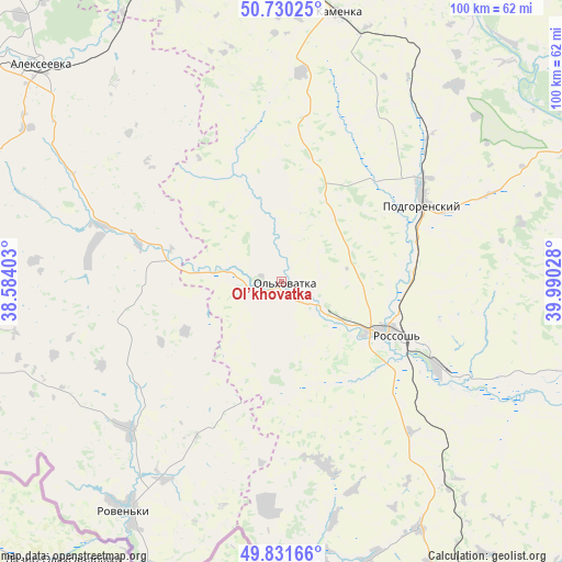
Ol’khovatka GPS coordinates[2]
50° 16' 59.088" North, 39° 17' 13.74" East
| Map corner | latitude | longitude |
|---|---|---|
| Upper-left | 50.73025°, | 38.58403° |
| Center: | 50.28308°, | 39.28715° |
| Lower-right: | 49.83166°, | 39.99028° |
| Map W x H: | 99.9×99.9 km | = 62.1×62.1mi |
| max Lat: | 73.50819° ⇑77.3% North |
| Ol’khovatka: | 50.28308° |
| min Lat: | ⇓22.7% South 41.28413° |
| min Long | Ol’khovatka | max Long |
| -179.12198° | 39.28715° | 179.35046° |
| W 29.1%⇐ | ⇒70.9% E |
Elevation
Elevation of Ol’khovatka is 117 m = 384 ft, and this is 85.6 m = 281 ft below average elevation for this country.
| Max E: |
2518 m = 8261 ft | 63.5% |
| Avg. | 202.6 m = 665 ft | |
| Ol’khovatka | 117 m = 384 ft | |
Min E: |
-28 m = -92 ft | 36.5% |
See also: Russia elevation on elevation.city.
Geographical zone
Ol’khovatka is located in North temperate zone (between Tropic of Cancer and the Arctic Circle). Distance of this North polar circle is 1810.2 km =1124.8 mi to North.| Distance of | km | miles | from Ol’khovatka |
|---|---|---|---|
| North Pole | 4416.1 | 2744 | to North |
| Arctic Circle | 1810.2 | 1124.8 | to North |
| Tropic Cancer | 2985 | 1854.8 | to South |
| Equator | 5591 | 3474.1 | to South |


Nearby cities:
15 places around Ol’khovatka: (largest is in red/bold)
• Alekseyevka
57.3 km =35.6 mi,  312°
312°
• Belogor’ye
56.2 km =34.9 mi,  65°
65°
• Ilovka
65.7 km =40.8 mi,  315°
315°
• Imeni Pervogo Maya
70.8 km =44 mi,  17°
17°
• Kamenka
49 km =30.4 mi,  11°
11°
• Livenka
72.7 km =45.2 mi,  284°
284°
• Losevo
69.2 km =43 mi,  50°
50°
• Mitrofanovka
45.2 km =28.1 mi,  140°
140°
• Ostrogozhsk
66.6 km =41.4 mi,  347°
347°
• Pavlovsk
61.4 km =38.2 mi, 71°
• Podgorenskiy
28.7 km =17.8 mi,  61°
61°
• Podgornoye
27.5 km =17.1 mi, 58°
• Rossosh’
22 km =13.7 mi,  115°
115°
• Veydelevka
61.4 km =38.2 mi,  256°
256°
• Zabolotovka
2 km =1.2 mi,  106°
106°
Sources, notices
• [Note1] Compared only with cities in Russia existing in our database
• [Src1] Map data: © OpenStreetMap contributors (CC-BY-SA)
• [Src2] Other city data from geonames.org with taken over terms of usage.
• [Src3] Geographical zone / Annual Mean Temperature by Robert A. Rohde @ Wikipedia
