L’govskiy geodata
L’govskiy (Kursk) is a populated place; located in Russia in Europe/Moscow (GMT+3) time zone. With population of 23,500 people, there are 783 cities with bigger population in this country. Compared to other cities in Russia, 71.7% of cities are located further ↑North; 88.6% of cities are located further →East and 55.9% of cities have lower elevation than L’govskiy. Note1


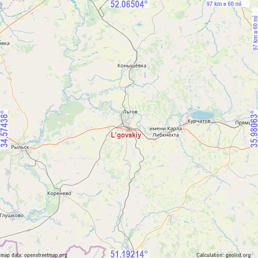
L’govskiy GPS coordinates[2]
51° 37' 50.484" North, 35° 16' 39" East
| Map corner | latitude | longitude |
|---|---|---|
| Upper-left | 52.06504°, | 34.57438° |
| Center: | 51.63069°, | 35.2775° |
| Lower-right: | 51.19214°, | 35.98063° |
| Map W x H: | 97.1×97.1 km | = 60.3×60.3mi |
| max Lat: | 73.50819° ⇑71.7% North |
| L’govskiy: | 51.63069° |
| min Lat: | ⇓28.3% South 41.28413° |
| min Long | L’govskiy | max Long |
| -179.12198° | 35.2775° | 179.35046° |
| W 11.4%⇐ | ⇒88.6% E |
Elevation
Elevation of L’govskiy is 158 m = 518 ft, and this is 44.6 m = 146 ft below average elevation for this country.
| Max E: |
2518 m = 8261 ft | 44.1% |
| Avg. | 202.6 m = 665 ft | |
| L’govskiy | 158 m = 518 ft | |
Min E: |
-28 m = -92 ft | 55.9% |
See also: Russia elevation on elevation.city.
Geographical zone
L’govskiy is located in North temperate zone (between Tropic of Cancer and the Arctic Circle). Distance of this North polar circle is 1660.4 km =1031.7 mi to North.| Distance of | km | miles | from L’govskiy |
|---|---|---|---|
| North Pole | 4266.3 | 2651 | to North |
| Arctic Circle | 1660.4 | 1031.7 | to North |
| Tropic Cancer | 3134.9 | 1947.9 | to South |
| Equator | 5740.8 | 3567.2 | to South |


Nearby cities:
15 places around L’govskiy: (largest is in red/bold)
• Chernitsyno
55.2 km =34.3 mi,  104°
104°
• Fatezh
64.9 km =40.3 mi,  38°
38°
• Glushkovo
55.2 km =34.3 mi,  234°
234°
• Ivanino
20.7 km =12.9 mi,  86°
86°
• Khomutovka
58.9 km =36.6 mi,  303°
303°
• Konyshevka
23.5 km =14.6 mi,  2°
2°
• Korenëvo
35.3 km =21.9 mi, 226°
• Kurchatov
26.1 km =16.2 mi,  82°
82°
• Kursk
63.8 km =39.6 mi, 79°
• Mikhaylovka
67.2 km =41.8 mi,  5°
5°
• Pervoavgustovskiy
68 km =42.3 mi,  347°
347°
• Pryamitsyno
45.2 km =28.1 mi, 86°
• Ryl’sk
41.8 km =26 mi,  260°
260°
• Sudzha
48.2 km =30 mi,  180°
180°
• Voroshnëvo
51.1 km =31.8 mi, 87°
Sources, notices
• [Note1] Compared only with cities in Russia existing in our database
• [Src1] Map data: © OpenStreetMap contributors (CC-BY-SA)
• [Src2] Other city data from geonames.org with taken over terms of usage.
• [Src3] Geographical zone / Annual Mean Temperature by Robert A. Rohde @ Wikipedia
