Voroshnëvo geodata
Voroshnëvo (Kursk) is a populated place; located in Russia in Europe/Moscow (GMT+3) time zone. With population of 3,244 people, there are 3571 cities with bigger population in this country. Compared to other cities in Russia, 71.6% of cities are located further ↑North; 87.3% of cities are located further →East and 58.8% of cities have lower elevation than Voroshnëvo. Note1


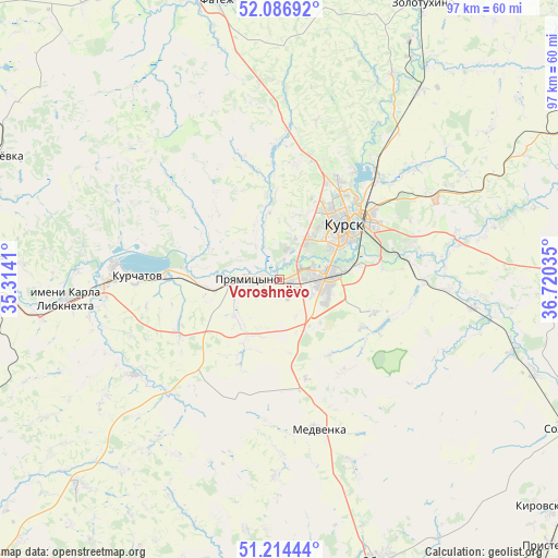
Voroshnëvo GPS coordinates[2]
51° 39' 10.008" North, 36° 1' 1.992" East
| Map corner | latitude | longitude |
|---|---|---|
| Upper-left | 52.08692°, | 35.3141° |
| Center: | 51.65278°, | 36.01722° |
| Lower-right: | 51.21444°, | 36.72035° |
| Map W x H: | 97×97 km | = 60.3×60.3mi |
| max Lat: | 73.50819° ⇑71.6% North |
| Voroshnëvo: | 51.65278° |
| min Lat: | ⇓28.4% South 41.28413° |
| min Long | Voroshnëvo | max Long |
| -179.12198° | 36.01722° | 179.35046° |
| W 12.7%⇐ | ⇒87.3% E |
Elevation
Elevation of Voroshnëvo is 165 m = 541 ft, and this is 37.6 m = 123 ft below average elevation for this country.
| Max E: |
2518 m = 8261 ft | 41.2% |
| Avg. | 202.6 m = 665 ft | |
| Voroshnëvo | 165 m = 541 ft | |
Min E: |
-28 m = -92 ft | 58.8% |
See also: Russia elevation on elevation.city.
Geographical zone
Voroshnëvo is located in North temperate zone (between Tropic of Cancer and the Arctic Circle). Distance of this North polar circle is 1657.9 km =1030.2 mi to North.| Distance of | km | miles | from Voroshnëvo |
|---|---|---|---|
| North Pole | 4263.8 | 2649.4 | to North |
| Arctic Circle | 1657.9 | 1030.2 | to North |
| Tropic Cancer | 3137.3 | 1949.4 | to South |
| Equator | 5743.3 | 3568.7 | to South |


Nearby cities:
15 places around Voroshnëvo: (largest is in red/bold)
• Chernitsyno
16.3 km =10.1 mi,  171°
171°
• Fatezh
49.7 km =30.9 mi,  347°
347°
• Ivanino
30.4 km =18.9 mi,  268°
268°
• Ivnya
66.1 km =41.1 mi, 172°
• Kirovskiy
52 km =32.3 mi,  120°
120°
• Konyshevka
54 km =33.6 mi,  292°
292°
• Kurchatov
25.2 km =15.7 mi, 271°
• Kursk
15 km =9.3 mi,  51°
51°
• L’govskiy
51.1 km =31.8 mi, 267°
• Oboyan’
52.5 km =32.6 mi,  159°
159°
• Pristen’
66.1 km =41.1 mi,  134°
134°
• Pryamitsyno
5.9 km =3.7 mi, 273°
• Shchigry
65.9 km =40.9 mi,  67°
67°
• Solntsevo
57 km =35.4 mi, 117°
• Zolotukhino
54 km =33.6 mi,  27°
27°
Sources, notices
• [Note1] Compared only with cities in Russia existing in our database
• [Src1] Map data: © OpenStreetMap contributors (CC-BY-SA)
• [Src2] Other city data from geonames.org with taken over terms of usage.
• [Src3] Geographical zone / Annual Mean Temperature by Robert A. Rohde @ Wikipedia
