Pryamitsyno geodata
Pryamitsyno (Kursk) is a populated place; located in Russia in Europe/Moscow (GMT+3) time zone. With population of 5,120 people, there are 2598 cities with bigger population in this country. Compared to other cities in Russia, 71.6% of cities are located further ↑North; 87.6% of cities are located further →East and 56.3% of cities have lower elevation than Pryamitsyno. Note1


Pryamitsyno GPS coordinates[2]
51° 39' 21.96" North, 35° 55' 53.04" East
| Map corner | latitude | longitude |
|---|---|---|
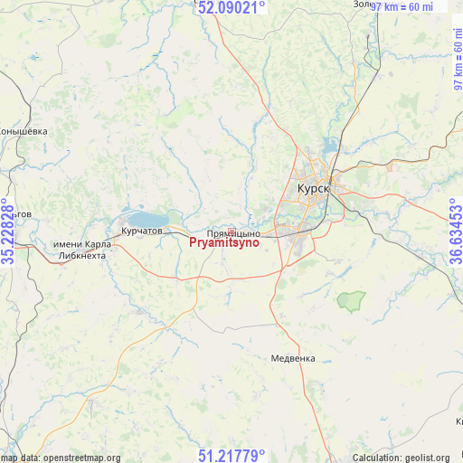
| Upper-left | 52.09021°, | 35.22828° |
| Center: | 51.6561°, | 35.9314° |
| Lower-right: | 51.21779°, | 36.63453° |
| Map W x H: | 97×97 km | = 60.3×60.3mi |
| max Lat: | 73.50819° ⇑71.6% North |
| Pryamitsyno: | 51.6561° |
| min Lat: | ⇓28.4% South 41.28413° |
| min Long | Pryamitsyno | max Long |
| -179.12198° | 35.9314° | 179.35046° |
| W 12.4%⇐ | ⇒87.6% E |
Elevation
Elevation of Pryamitsyno is 159 m = 522 ft, and this is 43.6 m = 143 ft below average elevation for this country.
| Max E: |
2518 m = 8261 ft | 43.7% |
| Avg. | 202.6 m = 665 ft | |
| Pryamitsyno | 159 m = 522 ft | |
Min E: |
-28 m = -92 ft | 56.3% |
See also: Russia elevation on elevation.city.
Geographical zone
Pryamitsyno is located in North temperate zone (between Tropic of Cancer and the Arctic Circle). Distance of this North polar circle is 1657.6 km =1030 mi to North.| Distance of | km | miles | from Pryamitsyno |
|---|---|---|---|
| North Pole | 4263.4 | 2649.2 | to North |
| Arctic Circle | 1657.6 | 1030 | to North |
| Tropic Cancer | 3137.7 | 1949.7 | to South |
| Equator | 5743.6 | 3568.9 | to South |


Nearby cities:
15 places around Pryamitsyno: (largest is in red/bold)
• Belaya
68.5 km =42.6 mi,  192°
192°
• Chernitsyno
18.5 km =11.5 mi,  153°
153°
• Fatezh
48.4 km =30.1 mi,  354°
354°
• Ivanino
24.5 km =15.2 mi,  266°
266°
• Ivnya
67.4 km =41.9 mi,  167°
167°
• Kirovskiy
57.4 km =35.7 mi,  117°
117°
• Konyshevka
48.5 km =30.1 mi,  295°
295°
• Kurchatov
19.3 km =12 mi, 271°
• Kursk
19.8 km =12.3 mi,  62°
62°
• L’govskiy
45.2 km =28.1 mi, 266°
• Oboyan’
55.2 km =34.3 mi, 154°
• Solntsevo
62.5 km =38.8 mi, 115°
• Sudzha
68.4 km =42.5 mi,  221°
221°
• Voroshnëvo
5.9 km =3.7 mi,  93°
93°
• Zolotukhino
56.6 km =35.2 mi,  32°
32°
Sources, notices
• [Note1] Compared only with cities in Russia existing in our database
• [Src1] Map data: © OpenStreetMap contributors (CC-BY-SA)
• [Src2] Other city data from geonames.org with taken over terms of usage.
• [Src3] Geographical zone / Annual Mean Temperature by Robert A. Rohde @ Wikipedia
