Letnik geodata
Letnik (Rostov) is a populated place; located in Russia in Europe/Moscow (GMT+3) time zone. With population of 3,141 people, there are 3658 cities with bigger population in this country. Compared to other cities in Russia, 84.1% of cities are located further ↑North; 62.1% of cities are located further →East and 85.8% of cities have higher elevation than Letnik. Note1


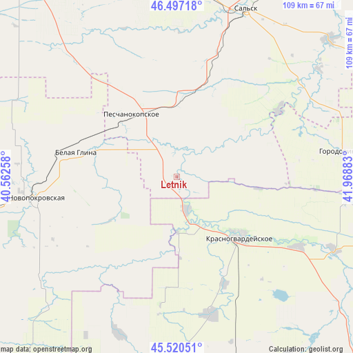
Letnik GPS coordinates[2]
46° 0' 39.6" North, 41° 15' 56.52" East
| Map corner | latitude | longitude |
|---|---|---|
| Upper-left | 46.49718°, | 40.56258° |
| Center: | 46.011°, | 41.2657° |
| Lower-right: | 45.52051°, | 41.96883° |
| Map W x H: | 108.6×108.6 km | = 67.5×67.5mi |
| max Lat: | 73.50819° ⇑84.1% North |
| Letnik: | 46.011° |
| min Lat: | ⇓15.9% South 41.28413° |
| min Long | Letnik | max Long |
| -179.12198° | 41.2657° | 179.35046° |
| W 37.9%⇐ | ⇒62.1% E |
Elevation
Elevation of Letnik is 44 m = 144 ft, and this is 158.6 m = 520 ft below average elevation for this country.
| Max E: |
2518 m = 8261 ft | 85.8% |
| Avg. | 202.6 m = 665 ft | |
| Letnik | 44 m = 144 ft | |
Min E: |
-28 m = -92 ft | 14.2% |
See also: Russia elevation on elevation.city.
Geographical zone
Letnik is located in North temperate zone (between Tropic of Cancer and the Arctic Circle). Distance of this North polar circle is 2285.2 km =1420 mi to North.| Distance of | km | miles | from Letnik |
|---|---|---|---|
| North Pole | 4891.1 | 3039.2 | to North |
| Arctic Circle | 2285.2 | 1420 | to North |
| Tropic Cancer | 2510 | 1559.6 | to South |
| Equator | 5115.9 | 3178.9 | to South |


Nearby cities:
15 places around Letnik: (largest is in red/bold)
• Belaya Glina
31.7 km =19.7 mi,  283°
283°
• Dmitriyevskaya
55.3 km =34.4 mi,  224°
224°
• Dmitriyevskoye
53.9 km =33.5 mi,  115°
115°
• Gigant
55.4 km =34.4 mi,  6°
6°
• Gorodovikovsk
52.2 km =32.4 mi,  80°
80°
• Krasnaya Polyana
21.4 km =13.3 mi,  58°
58°
• Krasnogvardeyskoye
26.8 km =16.7 mi,  133°
133°
• Kubanskiy
53.7 km =33.4 mi,  260°
260°
• Ladovskaya Balka
43.7 km =27.2 mi,  165°
165°
• Novopokrovskaya
44.2 km =27.5 mi, 261°
• Peschanokopskoye
24.9 km =15.5 mi,  325°
325°
• Pregradnoye
42.8 km =26.6 mi, 119°
• Rasshevatskaya
51.7 km =32.1 mi,  200°
200°
• Sandata
47.7 km =29.6 mi,  52°
52°
• Uspenskaya
31.4 km =19.5 mi,  209°
209°
Sources, notices
• [Note1] Compared only with cities in Russia existing in our database
• [Src1] Map data: © OpenStreetMap contributors (CC-BY-SA)
• [Src2] Other city data from geonames.org with taken over terms of usage.
• [Src3] Geographical zone / Annual Mean Temperature by Robert A. Rohde @ Wikipedia
