Ladovskaya Balka geodata
Ladovskaya Balka (Stavropol’ Kray) is a populated place; located in Russia in Europe/Moscow (GMT+3) time zone. With population of 5,117 people, there are 2600 cities with bigger population in this country. Compared to other cities in Russia, 85% of cities are located further ↑North; 61.7% of cities are located further →East and 71.5% of cities have higher elevation than Ladovskaya Balka. Note1


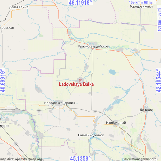
Ladovskaya Balka GPS coordinates[2]
45° 37' 46.74" North, 41° 24' 8.316" East
| Map corner | latitude | longitude |
|---|---|---|
| Upper-left | 46.11918°, | 40.69919° |
| Center: | 45.62965°, | 41.40231° |
| Lower-right: | 45.1358°, | 42.10544° |
| Map W x H: | 109.3×109.3 km | = 67.9×67.9mi |
| max Lat: | 73.50819° ⇑85% North |
| Ladovskaya Balka: | 45.62965° |
| min Lat: | ⇓15% South 41.28413° |
| min Long | Ladovskaya Balk | max Long |
| -179.12198° | 41.40231° | 179.35046° |
| W 38.3%⇐ | ⇒61.7% E |
Elevation
Elevation of Ladovskaya Balka is 99 m = 325 ft, and this is 103.6 m = 340 ft below average elevation for this country.
| Max E: |
2518 m = 8261 ft | 71.5% |
| Avg. | 202.6 m = 665 ft | |
| Ladovskaya Balka | 99 m = 325 ft | |
Min E: |
-28 m = -92 ft | 28.5% |
See also: Russia elevation on elevation.city.
Geographical zone
Ladovskaya Balka is located in North temperate zone (between Tropic of Cancer and the Arctic Circle). Distance of this North polar circle is 2327.6 km =1446.3 mi to North.| Distance of | km | miles | from Ladovskaya Balka |
|---|---|---|---|
| North Pole | 4933.5 | 3065.5 | to North |
| Arctic Circle | 2327.6 | 1446.3 | to North |
| Tropic Cancer | 2467.6 | 1533.3 | to South |
| Equator | 5073.5 | 3152.5 | to South |


Nearby cities:
15 places around Ladovskaya Balka: (largest is in red/bold)
• Bezopasnoye
41.5 km =25.8 mi,  87°
87°
• Dmitriyevskoye
43.1 km =26.8 mi,  63°
63°
• Donskoye
48.6 km =30.2 mi,  113°
113°
• Grigoropolisskaya
45.7 km =28.4 mi,  216°
216°
• Izobil’nyy
37.4 km =23.2 mi,  140°
140°
• Krasnogvardeyskoye
25.7 km =16 mi,  20°
20°
• Letnik
43.7 km =27.2 mi,  345°
345°
• Novoaleksandrovsk
20.6 km =12.8 mi, 223°
• Novotroitskaya
35 km =21.7 mi,  164°
164°
• Pregradnoye
34.2 km =21.3 mi,  51°
51°
• Rasshevatskaya
29.2 km =18.1 mi,  257°
257°
• Temizhbekskaya
34.6 km =21.5 mi,  234°
234°
• Temizhbekskaya
48 km =29.8 mi,  244°
244°
• Tishchenskoye
28.3 km =17.6 mi,  131°
131°
• Uspenskaya
30.1 km =18.7 mi,  299°
299°
Sources, notices
• [Note1] Compared only with cities in Russia existing in our database
• [Src1] Map data: © OpenStreetMap contributors (CC-BY-SA)
• [Src2] Other city data from geonames.org with taken over terms of usage.
• [Src3] Geographical zone / Annual Mean Temperature by Robert A. Rohde @ Wikipedia
