Kamenka geodata
Kamenka (Ivanovo) is a populated place; located in Russia in Europe/Moscow (GMT+3) time zone. With population of 4,124 people, there are 3042 cities with bigger population in this country. Compared to other cities in Russia, 79.5% of cities are located further ↓South; 60.5% of cities are located further →East and 71.5% of cities have higher elevation than Kamenka. Note1


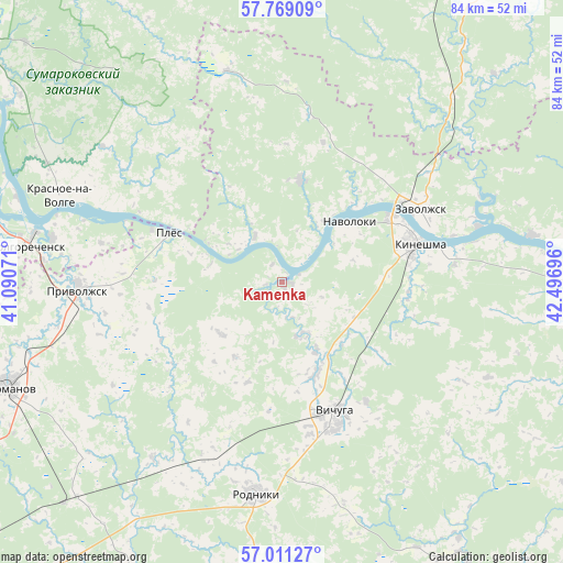
Kamenka GPS coordinates[2]
57° 23' 31.704" North, 41° 47' 37.788" East
| Map corner | latitude | longitude |
|---|---|---|
| Upper-left | 57.76909°, | 41.09071° |
| Center: | 57.39214°, | 41.79383° |
| Lower-right: | 57.01127°, | 42.49696° |
| Map W x H: | 84.3×84.3 km | = 52.4×52.4mi |
| max Lat: | 73.50819° ⇑20.5% North |
| Kamenka: | 57.39214° |
| min Lat: | ⇓79.5% South 41.28413° |
| min Long | Kamenka | max Long |
| -179.12198° | 41.79383° | 179.35046° |
| W 39.5%⇐ | ⇒60.5% E |
Elevation
Elevation of Kamenka is 99 m = 325 ft, and this is 103.6 m = 340 ft below average elevation for this country.
| Max E: |
2518 m = 8261 ft | 71.5% |
| Avg. | 202.6 m = 665 ft | |
| Kamenka | 99 m = 325 ft | |
Min E: |
-28 m = -92 ft | 28.5% |
See also: Russia elevation on elevation.city.
Geographical zone
Kamenka is located in North temperate zone (between Tropic of Cancer and the Arctic Circle). Distance of this North polar circle is 1019.8 km =633.7 mi to North.| Distance of | km | miles | from Kamenka |
|---|---|---|---|
| North Pole | 3625.7 | 2252.9 | to North |
| Arctic Circle | 1019.8 | 633.7 | to North |
| Tropic Cancer | 3775.5 | 2346 | to South |
| Equator | 6381.4 | 3965.2 | to South |


Nearby cities:
15 places around Kamenka: (largest is in red/bold)
• Furmanov
43.9 km =27.3 mi,  249°
249°
• Kaminskiy
33 km =20.5 mi,  215°
215°
• Kineshma
20.7 km =12.9 mi,  75°
75°
• Krasnoye-na-Volge
35.9 km =22.3 mi,  292°
292°
• Kuznechikha
37.9 km =23.5 mi,  121°
121°
• Navoloki
13 km =8.1 mi,  51°
51°
• Novopistsovo
8.6 km =5.3 mi,  155°
155°
• Plës
18.2 km =11.3 mi, 293°
• Privolzhsk
30.4 km =18.9 mi,  268°
268°
• Rodniki
32.1 km =19.9 mi,  186°
186°
• Staraya Vichuga
14.7 km =9.1 mi, 159°
• Vichuga
21.6 km =13.4 mi, 157°
• Volgorechensk
38.6 km =24 mi,  277°
277°
• Zarechnyy
30.6 km =19 mi,  73°
73°
• Zavolzhsk
22.9 km =14.2 mi,  64°
64°
Sources, notices
• [Note1] Compared only with cities in Russia existing in our database
• [Src1] Map data: © OpenStreetMap contributors (CC-BY-SA)
• [Src2] Other city data from geonames.org with taken over terms of usage.
• [Src3] Geographical zone / Annual Mean Temperature by Robert A. Rohde @ Wikipedia
