Koz’modem’yansk geodata
Koz’modem’yansk (Mariy-El Republic) is a populated place; located in Russia in Europe/Moscow (GMT+3) time zone. With population of 22,700 people, there are 797 cities with bigger population in this country. Compared to other cities in Russia, 71% of cities are located further ↓South; 54.4% of cities are located further ←West and 67.2% of cities have higher elevation than Koz’modem’yansk. Note1


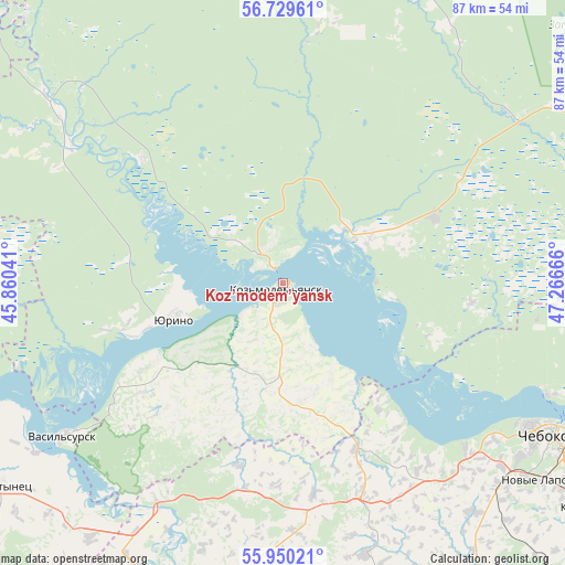
Koz’modem’yansk GPS coordinates[2]
56° 20' 30.84" North, 46° 33' 48.708" East
| Map corner | latitude | longitude |
|---|---|---|
| Upper-left | 56.72961°, | 45.86041° |
| Center: | 56.3419°, | 46.56353° |
| Lower-right: | 55.95021°, | 47.26666° |
| Map W x H: | 86.7×86.7 km | = 53.9×53.9mi |
| max Lat: | 73.50819° ⇑29% North |
| Koz’modem’yansk: | 56.3419° |
| min Lat: | ⇓71% South 41.28413° |
| min Long | Koz’modem’y | max Long |
| -179.12198° | 46.56353° | 179.35046° |
| W 54.4%⇐ | ⇒45.6% E |
Elevation
Elevation of Koz’modem’yansk is 109 m = 358 ft, and this is 93.6 m = 307 ft below average elevation for this country.
| Max E: |
2518 m = 8261 ft | 67.2% |
| Avg. | 202.6 m = 665 ft | |
| Koz’modem’yansk | 109 m = 358 ft | |
Min E: |
-28 m = -92 ft | 32.8% |
See also: Russia elevation on elevation.city.
Geographical zone
Koz’modem’yansk is located in North temperate zone (between Tropic of Cancer and the Arctic Circle). Distance of this North polar circle is 1136.5 km =706.2 mi to North.| Distance of | km | miles | from Koz’modem’yansk |
|---|---|---|---|
| North Pole | 3742.4 | 2325.4 | to North |
| Arctic Circle | 1136.5 | 706.2 | to North |
| Tropic Cancer | 3658.7 | 2273.4 | to South |
| Equator | 6264.6 | 3892.6 | to South |


Nearby cities:
15 places around Koz’modem’yansk: (largest is in red/bold)
• Alikovo
68.2 km =42.4 mi,  169°
169°
• Atlashevo
71.5 km =44.4 mi,  120°
120°
• Cheboksary
48.5 km =30.1 mi, 118°
• Ishley
46.5 km =28.9 mi,  139°
139°
• Kilemary
51.9 km =32.2 mi,  20°
20°
• Krasnoarmeyskoye
74.2 km =46.1 mi,  149°
149°
• Kugesi
57 km =35.4 mi,  127°
127°
• Morgaushi
44 km =27.3 mi,  162°
162°
• Novocheboksarsk
62.1 km =38.6 mi,  114°
114°
• Novyye Lapsary
50.4 km =31.3 mi, 127°
• Vasil’sursk
41.1 km =25.5 mi,  235°
235°
• Vilovatovo
19 km =11.8 mi, 172°
• Vorotynets
53.4 km =33.2 mi,  234°
234°
• Yadrin
49.8 km =30.9 mi,  206°
206°
• Yurino
16.9 km =10.5 mi,  251°
251°
Sources, notices
• [Note1] Compared only with cities in Russia existing in our database
• [Src1] Map data: © OpenStreetMap contributors (CC-BY-SA)
• [Src2] Other city data from geonames.org with taken over terms of usage.
• [Src3] Geographical zone / Annual Mean Temperature by Robert A. Rohde @ Wikipedia
