Vorotynets geodata
Vorotynets (Nizhny Novgorod Oblast) is a populated place; located in Russia in Europe/Moscow (GMT+3) time zone. With population of 6,151 people, there are 2214 cities with bigger population in this country. Compared to other cities in Russia, 67.5% of cities are located further ↓South; 52.4% of cities are located further ←West and 73.4% of cities have higher elevation than Vorotynets. Note1


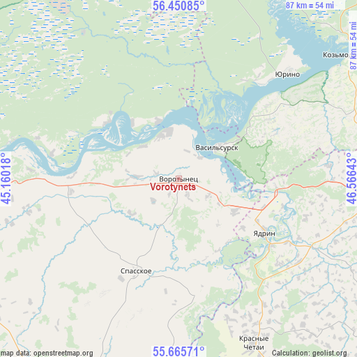
Vorotynets GPS coordinates[2]
56° 3' 37.008" North, 45° 51' 47.88" East
| Map corner | latitude | longitude |
|---|---|---|
| Upper-left | 56.45085°, | 45.16018° |
| Center: | 56.06028°, | 45.8633° |
| Lower-right: | 55.66571°, | 46.56643° |
| Map W x H: | 87.3×87.3 km | = 54.2×54.2mi |
| max Lat: | 73.50819° ⇑32.5% North |
| Vorotynets: | 56.06028° |
| min Lat: | ⇓67.5% South 41.28413° |
| min Long | Vorotynets | max Long |
| -179.12198° | 45.8633° | 179.35046° |
| W 52.4%⇐ | ⇒47.6% E |
Elevation
Elevation of Vorotynets is 93 m = 305 ft, and this is 109.6 m = 360 ft below average elevation for this country.
| Max E: |
2518 m = 8261 ft | 73.4% |
| Avg. | 202.6 m = 665 ft | |
| Vorotynets | 93 m = 305 ft | |
Min E: |
-28 m = -92 ft | 26.6% |
See also: Russia elevation on elevation.city.
Geographical zone
Vorotynets is located in North temperate zone (between Tropic of Cancer and the Arctic Circle). Distance of this North polar circle is 1167.9 km =725.7 mi to North.| Distance of | km | miles | from Vorotynets |
|---|---|---|---|
| North Pole | 3773.7 | 2344.9 | to North |
| Arctic Circle | 1167.9 | 725.7 | to North |
| Tropic Cancer | 3627.4 | 2254 | to South |
| Equator | 6233.3 | 3873.2 | to South |


Nearby cities:
15 places around Vorotynets: (largest is in red/bold)
• Alikovo
66.1 km =41.1 mi,  122°
122°
• Knyaginino
58 km =36 mi,  242°
242°
• Koz’modem’yansk
53.4 km =33.2 mi,  54°
54°
• Krasnyye Chetai
44.7 km =27.8 mi,  157°
157°
• Lyskovo
51.1 km =31.8 mi,  266°
266°
• Morgaushi
57.6 km =35.8 mi,  100°
100°
• Pervoye Maya
71.8 km =44.6 mi,  279°
279°
• Pil’na
56.4 km =35 mi,  176°
176°
• Sergach
63.9 km =39.7 mi,  202°
202°
• Shumerlya
71.1 km =44.2 mi,  151°
151°
• Spasskoye
24.5 km =15.2 mi, 204°
• Vasil’sursk
12.3 km =7.6 mi, 50°
• Vilovatovo
47.4 km =29.5 mi,  74°
74°
• Yadrin
25.1 km =15.6 mi, 121°
• Yurino
37.7 km =23.4 mi, 46°
Sources, notices
• [Note1] Compared only with cities in Russia existing in our database
• [Src1] Map data: © OpenStreetMap contributors (CC-BY-SA)
• [Src2] Other city data from geonames.org with taken over terms of usage.
• [Src3] Geographical zone / Annual Mean Temperature by Robert A. Rohde @ Wikipedia
