Khvastovichi geodata
Khvastovichi (Kaluga) is a populated place; located in Russia in Europe/Moscow (GMT+3) time zone. With population of 4,545 people, there are 2853 cities with bigger population in this country. Compared to other cities in Russia, 58.9% of cities are located further ↑North; 88.9% of cities are located further →East and 63.8% of cities have lower elevation than Khvastovichi. Note1


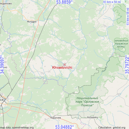
Khvastovichi GPS coordinates[2]
53° 28' 9.912" North, 35° 5' 38.724" East
| Map corner | latitude | longitude |
|---|---|---|
| Upper-left | 53.8859°, | 34.39097° |
| Center: | 53.46942°, | 35.09409° |
| Lower-right: | 53.04882°, | 35.79722° |
| Map W x H: | 93.1×93.1 km | = 57.8×57.8mi |
| max Lat: | 73.50819° ⇑58.9% North |
| Khvastovichi: | 53.46942° |
| min Lat: | ⇓41.1% South 41.28413° |
| min Long | Khvastovichi | max Long |
| -179.12198° | 35.09409° | 179.35046° |
| W 11.1%⇐ | ⇒88.9% E |
Elevation
Elevation of Khvastovichi is 179 m = 587 ft, and this is 23.6 m = 77 ft below average elevation for this country.
| Max E: |
2518 m = 8261 ft | 36.2% |
| Avg. | 202.6 m = 665 ft | |
| Khvastovichi | 179 m = 587 ft | |
Min E: |
-28 m = -92 ft | 63.8% |
See also: Russia elevation on elevation.city.
Geographical zone
Khvastovichi is located in North temperate zone (between Tropic of Cancer and the Arctic Circle). Distance of this North polar circle is 1455.9 km =904.7 mi to North.| Distance of | km | miles | from Khvastovichi |
|---|---|---|---|
| North Pole | 4061.8 | 2523.9 | to North |
| Arctic Circle | 1455.9 | 904.7 | to North |
| Tropic Cancer | 3339.3 | 2074.9 | to South |
| Equator | 5945.2 | 3694.2 | to South |


Nearby cities:
15 places around Khvastovichi: (largest is in red/bold)
• Belyye Berega
40.7 km =25.3 mi,  224°
224°
• Bolkhov
60.4 km =37.5 mi,  92°
92°
• Bryansk
53.7 km =33.4 mi,  243°
243°
• Duminichi
51.7 km =32.1 mi,  1°
1°
• Dyat’kovo
52 km =32.3 mi,  285°
285°
• Ivanovka
59.6 km =37 mi,  256°
256°
• Karachev
39.2 km =24.4 mi,  190°
190°
• Khotynets
42.9 km =26.7 mi,  152°
152°
• Lyubokhna
46.8 km =29.1 mi,  274°
274°
• Putëvka
58.4 km =36.3 mi,  246°
246°
• Raditsa-Krylovka
51.7 km =32.1 mi, 250°
• Sven’
48.2 km =30 mi,  228°
228°
• Zarech’ye
45.9 km =28.5 mi,  50°
50°
• Zhizdra
38.6 km =24 mi,  322°
322°
• Znamenskoye
44.9 km =27.9 mi,  118°
118°
Sources, notices
• [Note1] Compared only with cities in Russia existing in our database
• [Src1] Map data: © OpenStreetMap contributors (CC-BY-SA)
• [Src2] Other city data from geonames.org with taken over terms of usage.
• [Src3] Geographical zone / Annual Mean Temperature by Robert A. Rohde @ Wikipedia
