Dyat’kovo geodata
Dyat’kovo (Bryansk Oblast) is a populated place; located in Russia in Europe/Moscow (GMT+3) time zone. With population of 33,200 people, there are 605 cities with bigger population in this country. Compared to other cities in Russia, 58.1% of cities are located further ↑North; 89.9% of cities are located further →East and 72.3% of cities have lower elevation than Dyat’kovo. Note1


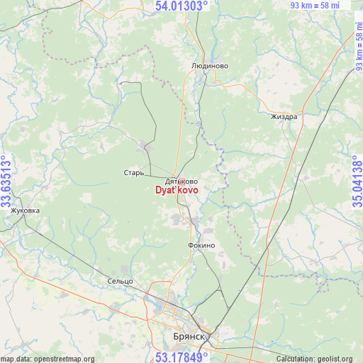
Dyat’kovo GPS coordinates[2]
53° 35' 52.152" North, 34° 20' 17.7" East
| Map corner | latitude | longitude |
|---|---|---|
| Upper-left | 54.01303°, | 33.63513° |
| Center: | 53.59782°, | 34.33825° |
| Lower-right: | 53.17849°, | 35.04138° |
| Map W x H: | 92.8×92.8 km | = 57.7×57.7mi |
| max Lat: | 73.50819° ⇑58.1% North |
| Dyat’kovo: | 53.59782° |
| min Lat: | ⇓41.9% South 41.28413° |
| min Long | Dyat’kovo | max Long |
| -179.12198° | 34.33825° | 179.35046° |
| W 10.1%⇐ | ⇒89.9% E |
Elevation
Elevation of Dyat’kovo is 206 m = 676 ft, and this is 3.4 m = 11 ft above average elevation for this country.
| Max E: |
2518 m = 8261 ft | 27.7% |
| Dyat’kovo | 206 m 676 ft | |
| Avg. | 202.6 m = 665 ft | |
Min E: |
-28 m = -92 ft | 72.3% |
See also: Russia elevation on elevation.city.
Geographical zone
Dyat’kovo is located in North temperate zone (between Tropic of Cancer and the Arctic Circle). Distance of this North polar circle is 1441.7 km =895.8 mi to North.| Distance of | km | miles | from Dyat’kovo |
|---|---|---|---|
| North Pole | 4047.5 | 2515 | to North |
| Arctic Circle | 1441.7 | 895.8 | to North |
| Tropic Cancer | 3353.6 | 2083.8 | to South |
| Equator | 5959.5 | 3703.1 | to South |


Nearby cities:
15 places around Dyat’kovo: (largest is in red/bold)
• Bryansk
38.5 km =23.9 mi,  176°
176°
• Bytosh’
29.4 km =18.3 mi,  326°
326°
• Glinishchevo
37.3 km =23.2 mi,  208°
208°
• Ivanovka
29 km =18 mi,  195°
195°
• Ivot
13.2 km =8.2 mi,  310°
310°
• Lyubokhna
11 km =6.8 mi,  162°
162°
• Lyudinovo
30.7 km =19.1 mi,  13°
13°
• Net’inka
29.5 km =18.3 mi, 199°
• Ovstug
40 km =24.9 mi,  230°
230°
• Putëvka
37.9 km =23.5 mi,  185°
185°
• Raditsa-Krylovka
31.2 km =19.4 mi, 177°
• Rzhanitsa
33.3 km =20.7 mi,  235°
235°
• Sel’tso
29.9 km =18.6 mi, 211°
• Star’
12.6 km =7.8 mi,  283°
283°
• Zhizdra
31.1 km =19.3 mi,  58°
58°
Sources, notices
• [Note1] Compared only with cities in Russia existing in our database
• [Src1] Map data: © OpenStreetMap contributors (CC-BY-SA)
• [Src2] Other city data from geonames.org with taken over terms of usage.
• [Src3] Geographical zone / Annual Mean Temperature by Robert A. Rohde @ Wikipedia
