Karachev geodata
Karachev (Bryansk Oblast) is a populated place; located in Russia in Europe/Moscow (GMT+3) time zone. With population of 19,757 people, there are 878 cities with bigger population in this country. Compared to other cities in Russia, 62.1% of cities are located further ↑North; 89% of cities are located further →East and 71.9% of cities have lower elevation than Karachev. Note1


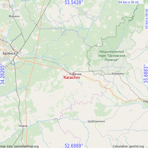
Karachev GPS coordinates[2]
53° 7' 22.512" North, 34° 59' 6.612" East
| Map corner | latitude | longitude |
|---|---|---|
| Upper-left | 53.5428°, | 34.28205° |
| Center: | 53.12292°, | 34.98517° |
| Lower-right: | 52.6989°, | 35.6883° |
| Map W x H: | 93.8×93.8 km | = 58.3×58.3mi |
| max Lat: | 73.50819° ⇑62.1% North |
| Karachev: | 53.12292° |
| min Lat: | ⇓37.9% South 41.28413° |
| min Long | Karachev | max Long |
| -179.12198° | 34.98517° | 179.35046° |
| W 11%⇐ | ⇒89% E |
Elevation
Elevation of Karachev is 204 m = 669 ft, and this is 1.4 m = 5 ft above average elevation for this country.
| Max E: |
2518 m = 8261 ft | 28.1% |
| Karachev | 204 m 669 ft | |
| Avg. | 202.6 m = 665 ft | |
Min E: |
-28 m = -92 ft | 71.9% |
See also: Russia elevation on elevation.city.
Geographical zone
Karachev is located in North temperate zone (between Tropic of Cancer and the Arctic Circle). Distance of this North polar circle is 1494.5 km =928.6 mi to North.| Distance of | km | miles | from Karachev |
|---|---|---|---|
| North Pole | 4100.3 | 2547.8 | to North |
| Arctic Circle | 1494.5 | 928.6 | to North |
| Tropic Cancer | 3300.8 | 2051 | to South |
| Equator | 5906.7 | 3670.3 | to South |


Nearby cities:
15 places around Karachev: (largest is in red/bold)
• Belyye Berega
23.4 km =14.5 mi,  293°
293°
• Bryansk
43.3 km =26.9 mi, 289°
• Dobrun’
49.8 km =30.9 mi,  277°
277°
• Ivanovka
56.7 km =35.2 mi,  296°
296°
• Khotynets
27.5 km =17.1 mi,  88°
88°
• Khvastovichi
39.2 km =24.4 mi,  10°
10°
• Naryshkino
52.5 km =32.6 mi,  109°
109°
• Navlya
46.4 km =28.8 mi,  224°
224°
• Putëvka
48.8 km =30.3 mi, 287°
• Raditsa-Krylovka
47 km =29.2 mi, 297°
• Shablykino
32.8 km =20.4 mi,  154°
154°
• Soskovo
49.5 km =30.8 mi, 147°
• Suponevo
46.8 km =29.1 mi, 281°
• Sven’
29.7 km =18.5 mi, 282°
• Znamenskoye
50.1 km =31.1 mi,  69°
69°
Sources, notices
• [Note1] Compared only with cities in Russia existing in our database
• [Src1] Map data: © OpenStreetMap contributors (CC-BY-SA)
• [Src2] Other city data from geonames.org with taken over terms of usage.
• [Src3] Geographical zone / Annual Mean Temperature by Robert A. Rohde @ Wikipedia
