Khasavyurt geodata
Khasavyurt (Dagestan) is a seat of a second-order administrative division; located in Russia in Europe/Moscow (GMT+3) time zone. With population of 126,829 people, there are 161 cities with bigger population in this country. Compared to other cities in Russia, 95.8% of cities are located further ↑North; 54.5% of cities are located further ←West and 57.7% of cities have higher elevation than Khasavyurt. Note1


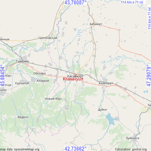
Khasavyurt GPS coordinates[2]
43° 15' 3.24" North, 46° 35' 15.576" East
| Map corner | latitude | longitude |
|---|---|---|
| Upper-left | 43.76087°, | 45.88454° |
| Center: | 43.2509°, | 46.58766° |
| Lower-right: | 42.73662°, | 47.29079° |
| Map W x H: | 113.9×113.9 km | = 70.8×70.8mi |
| max Lat: | 73.50819° ⇑95.8% North |
| Khasavyurt: | 43.2509° |
| min Lat: | ⇓4.2% South 41.28413° |
| min Long | Khasavyurt | max Long |
| -179.12198° | 46.58766° | 179.35046° |
| W 54.5%⇐ | ⇒45.5% E |
Elevation
Elevation of Khasavyurt is 129 m = 423 ft, and this is 73.6 m = 241 ft below average elevation for this country.
| Max E: |
2518 m = 8261 ft | 57.7% |
| Avg. | 202.6 m = 665 ft | |
| Khasavyurt | 129 m = 423 ft | |
Min E: |
-28 m = -92 ft | 42.3% |
See also: Khasavyurt elevation on elevation.city.
Geographical zone
Khasavyurt is located in North temperate zone (between Tropic of Cancer and the Arctic Circle). Distance of this Northern Tropic circle is 2203.1 km =1368.9 mi to South.| Distance of | km | miles | from Khasavyurt |
|---|---|---|---|
| North Pole | 5198 | 3229.9 | to North |
| Arctic Circle | 2592.1 | 1610.7 | to North |
| Tropic Cancer | 2203.1 | 1368.9 | to South |
| Equator | 4809 | 2988.2 | to South |


Nearby cities:
15 places around Khasavyurt: (largest is in red/bold)
• Aksay
17.8 km =11.1 mi,  319°
319°
• Bammatyurt
10.7 km =6.6 mi,  8°
8°
• Botashyurt
8.9 km =5.5 mi, 315°
• Botayurt
10.8 km =6.7 mi,  45°
45°
• Endirey
11.1 km =6.9 mi,  151°
151°
• Gerzel’-Aul
15 km =9.3 mi,  268°
268°
• Ishkhoy-Yurt
16.6 km =10.3 mi,  255°
255°
• Kokrek
11.4 km =7.1 mi,  98°
98°
• Leninaul
17.8 km =11.1 mi,  183°
183°
• Mutsalaul
11.9 km =7.4 mi,  76°
76°
• Novolakskoye
16.9 km =10.5 mi,  210°
210°
• Nuradilovo
11.2 km =7 mi,  289°
289°
• Pokrovskoye
7.6 km =4.7 mi,  56°
56°
• Solnechnoye
7.1 km =4.4 mi, 293°
• Zubutli-Miatli
19.1 km =11.9 mi,  107°
107°
Sources, notices
• [Note1] Compared only with cities in Russia existing in our database
• [Src1] Map data: © OpenStreetMap contributors (CC-BY-SA)
• [Src2] Other city data from geonames.org with taken over terms of usage.
• [Src3] Geographical zone / Annual Mean Temperature by Robert A. Rohde @ Wikipedia
