Leninaul geodata
Leninaul (Dagestan) is a populated place; located in Russia in Europe/Moscow (GMT+3) time zone. With population of 7,503 people, there are 1903 cities with bigger population in this country. Compared to other cities in Russia, 97.2% of cities are located further ↑North; 54.4% of cities are located further ←West and 92.2% of cities have lower elevation than Leninaul. Note1


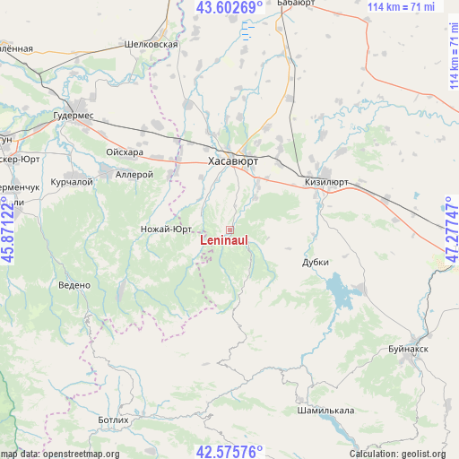
Leninaul GPS coordinates[2]
43° 5' 28.968" North, 46° 34' 27.624" East
| Map corner | latitude | longitude |
|---|---|---|
| Upper-left | 43.60269°, | 45.87122° |
| Center: | 43.09138°, | 46.57434° |
| Lower-right: | 42.57576°, | 47.27747° |
| Map W x H: | 114.2×114.2 km | = 71×71mi |
| max Lat: | 73.50819° ⇑97.2% North |
| Leninaul: | 43.09138° |
| min Lat: | ⇓2.8% South 41.28413° |
| min Long | Leninaul | max Long |
| -179.12198° | 46.57434° | 179.35046° |
| W 54.4%⇐ | ⇒45.6% E |
Elevation
Elevation of Leninaul is 512 m = 1680 ft, and this is 309.4 m = 1015 ft above average elevation for this country.
| Max E: |
2518 m = 8261 ft | 7.8% |
| Leninaul | 512 m 1680 ft | |
| Avg. | 202.6 m = 665 ft | |
Min E: |
-28 m = -92 ft | 92.2% |
See also: Russia elevation on elevation.city.
Geographical zone
Leninaul is located in North temperate zone (between Tropic of Cancer and the Arctic Circle). Distance of this Northern Tropic circle is 2185.4 km =1357.9 mi to South.| Distance of | km | miles | from Leninaul |
|---|---|---|---|
| North Pole | 5215.7 | 3240.9 | to North |
| Arctic Circle | 2609.9 | 1621.7 | to North |
| Tropic Cancer | 2185.4 | 1357.9 | to South |
| Equator | 4791.3 | 2977.2 | to South |


Nearby cities:
15 places around Leninaul: (largest is in red/bold)
• Bavtugay
22.7 km =14.1 mi,  67°
67°
• Burtunay
12.3 km =7.6 mi,  158°
158°
• Dylym
5.4 km =3.4 mi,  114°
114°
• Endirey
10.3 km =6.4 mi,  39°
39°
• Gerzel’-Aul
22.2 km =13.8 mi,  321°
321°
• Ishkhoy-Yurt
20.2 km =12.6 mi,  311°
311°
• Kalininaul
2.3 km =1.4 mi,  195°
195°
• Khasavyurt
17.8 km =11.1 mi,  3°
3°
• Kokrek
20.3 km =12.6 mi, 37°
• Miatli
20.7 km =12.9 mi,  92°
92°
• Novolakskoye
8.1 km =5 mi,  292°
292°
• Nozhay-Yurt
15.9 km =9.9 mi,  270°
270°
• Solnechnoye
21.2 km =13.2 mi,  345°
345°
• Zandak
10.4 km =6.5 mi,  248°
248°
• Zubutli-Miatli
22.7 km =14.1 mi,  58°
58°
Sources, notices
• [Note1] Compared only with cities in Russia existing in our database
• [Src1] Map data: © OpenStreetMap contributors (CC-BY-SA)
• [Src2] Other city data from geonames.org with taken over terms of usage.
• [Src3] Geographical zone / Annual Mean Temperature by Robert A. Rohde @ Wikipedia
