Khanino geodata
Khanino (Tula) is a populated place; located in Russia in Europe/Moscow (GMT+3) time zone. With population of 1,256 people, there are 4493 cities with bigger population in this country. Compared to other cities in Russia, 53.4% of cities are located further ↑North; 85.9% of cities are located further →East and 69.5% of cities have lower elevation than Khanino. Note1


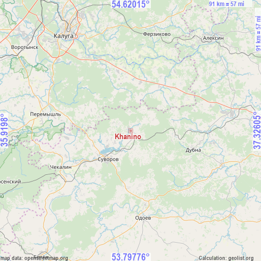
Khanino GPS coordinates[2]
54° 12' 39.6" North, 36° 37' 22.512" East
| Map corner | latitude | longitude |
|---|---|---|
| Upper-left | 54.62015°, | 35.9198° |
| Center: | 54.211°, | 36.62292° |
| Lower-right: | 53.79776°, | 37.32605° |
| Map W x H: | 91.4×91.4 km | = 56.8×56.8mi |
| max Lat: | 73.50819° ⇑53.4% North |
| Khanino: | 54.211° |
| min Lat: | ⇓46.6% South 41.28413° |
| min Long | Khanino | max Long |
| -179.12198° | 36.62292° | 179.35046° |
| W 14.1%⇐ | ⇒85.9% E |
Elevation
Elevation of Khanino is 196 m = 643 ft, and this is 6.6 m = 22 ft below average elevation for this country.
| Max E: |
2518 m = 8261 ft | 30.5% |
| Avg. | 202.6 m = 665 ft | |
| Khanino | 196 m = 643 ft | |
Min E: |
-28 m = -92 ft | 69.5% |
See also: Russia elevation on elevation.city.
Geographical zone
Khanino is located in North temperate zone (between Tropic of Cancer and the Arctic Circle). Distance of this North polar circle is 1373.5 km =853.5 mi to North.| Distance of | km | miles | from Khanino |
|---|---|---|---|
| North Pole | 3979.4 | 2472.7 | to North |
| Arctic Circle | 1373.5 | 853.5 | to North |
| Tropic Cancer | 3421.8 | 2126.2 | to South |
| Equator | 6027.7 | 3745.4 | to South |


Nearby cities:
15 places around Khanino: (largest is in red/bold)
• Ageyevo
11.6 km =7.2 mi,  239°
239°
• Aleksin
43.6 km =27.1 mi,  41°
41°
• Avchurino
30.1 km =18.7 mi,  335°
335°
• Chekalin
27.7 km =17.2 mi, 242°
• Cherepet’
19 km =11.8 mi, 236°
• Dubna
22.9 km =14.2 mi,  105°
105°
• Dugna
26.5 km =16.5 mi,  34°
34°
• Ferzikovo
35.3 km =21.9 mi,  14°
14°
• Kaluga
41.9 km =26 mi,  327°
327°
• Krapivna
45.9 km =28.5 mi,  130°
130°
• Odoyev
30.5 km =19 mi,  172°
172°
• Peremyshl’
30.6 km =19 mi,  280°
280°
• Pesochenskiy
33.6 km =20.9 mi,  263°
263°
• Suvorov
12.8 km =8 mi,  219°
219°
• Vorotynsk
44.5 km =27.7 mi,  302°
302°
Sources, notices
• [Note1] Compared only with cities in Russia existing in our database
• [Src1] Map data: © OpenStreetMap contributors (CC-BY-SA)
• [Src2] Other city data from geonames.org with taken over terms of usage.
• [Src3] Geographical zone / Annual Mean Temperature by Robert A. Rohde @ Wikipedia
