Dugna geodata
Dugna (Kaluga) is a populated place; located in Russia in Europe/Moscow (GMT+3) time zone. With population of 783 people, there are 4768 cities with bigger population in this country. Compared to other cities in Russia, 51.9% of cities are located further ↑North; 85.3% of cities are located further →East and 51.1% of cities have higher elevation than Dugna. Note1


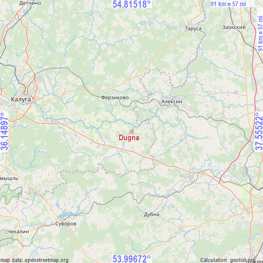
Dugna GPS coordinates[2]
54° 24' 28.764" North, 36° 51' 7.524" East
| Map corner | latitude | longitude |
|---|---|---|
| Upper-left | 54.81518°, | 36.14897° |
| Center: | 54.40799°, | 36.85209° |
| Lower-right: | 53.99672°, | 37.55522° |
| Map W x H: | 91×91 km | = 56.5×56.5mi |
| max Lat: | 73.50819° ⇑51.9% North |
| Dugna: | 54.40799° |
| min Lat: | ⇓48.1% South 41.28413° |
| min Long | Dugna | max Long |
| -179.12198° | 36.85209° | 179.35046° |
| W 14.7%⇐ | ⇒85.3% E |
Elevation
Elevation of Dugna is 142 m = 466 ft, and this is 60.6 m = 199 ft below average elevation for this country.
| Max E: |
2518 m = 8261 ft | 51.1% |
| Avg. | 202.6 m = 665 ft | |
| Dugna | 142 m = 466 ft | |
Min E: |
-28 m = -92 ft | 48.9% |
See also: Russia elevation on elevation.city.
Geographical zone
Dugna is located in North temperate zone (between Tropic of Cancer and the Arctic Circle). Distance of this North polar circle is 1351.6 km =839.8 mi to North.| Distance of | km | miles | from Dugna |
|---|---|---|---|
| North Pole | 3957.5 | 2459.1 | to North |
| Arctic Circle | 1351.6 | 839.8 | to North |
| Tropic Cancer | 3443.7 | 2139.8 | to South |
| Equator | 6049.6 | 3759 | to South |


Nearby cities:
15 places around Dugna: (largest is in red/bold)
• Ageyevo
37.2 km =23.1 mi,  221°
221°
• Aleksin
17.6 km =10.9 mi,  52°
52°
• Avchurino
27.9 km =17.3 mi,  281°
281°
• Barsuki
44.1 km =27.4 mi,  111°
111°
• Cherepet’
44.6 km =27.7 mi, 223°
• Dubna
29.1 km =18.1 mi,  165°
165°
• Ferzikovo
13.8 km =8.6 mi,  333°
333°
• Kaluga
39.6 km =24.6 mi,  289°
289°
• Khanino
26.5 km =16.5 mi,  214°
214°
• Leninskiy
41.6 km =25.8 mi, 108°
• Novogurovskiy
32.1 km =19.9 mi,  78°
78°
• Peremyshl’
47.6 km =29.6 mi,  250°
250°
• Strakhovo
45.2 km =28.1 mi,  36°
36°
• Suvorov
39.3 km =24.4 mi, 216°
• Tarusa
40.8 km =25.4 mi,  30°
30°
Sources, notices
• [Note1] Compared only with cities in Russia existing in our database
• [Src1] Map data: © OpenStreetMap contributors (CC-BY-SA)
• [Src2] Other city data from geonames.org with taken over terms of usage.
• [Src3] Geographical zone / Annual Mean Temperature by Robert A. Rohde @ Wikipedia
