Katunino geodata
Katunino (Arkhangelskaya) is a populated place; located in Russia in Europe/Moscow (GMT+3) time zone. With population of 3,255 people, there are 3564 cities with bigger population in this country. Compared to other cities in Russia, 97.1% of cities are located further ↓South; 64.5% of cities are located further →East and 92.5% of cities have higher elevation than Katunino. Note1


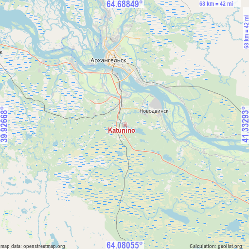
Katunino GPS coordinates[2]
64° 23' 10.32" North, 40° 37' 47.28" East
| Map corner | latitude | longitude |
|---|---|---|
| Upper-left | 64.68849°, | 39.92668° |
| Center: | 64.3862°, | 40.6298° |
| Lower-right: | 64.08055°, | 41.33293° |
| Map W x H: | 67.6×67.6 km | = 42×42mi |
| max Lat: | 73.50819° ⇑2.9% North |
| Katunino: | 64.3862° |
| min Lat: | ⇓97.1% South 41.28413° |
| min Long | Katunino | max Long |
| -179.12198° | 40.6298° | 179.35046° |
| W 35.5%⇐ | ⇒64.5% E |
Elevation
Elevation of Katunino is 20 m = 66 ft, and this is 182.6 m = 599 ft below average elevation for this country.
| Max E: |
2518 m = 8261 ft | 92.5% |
| Avg. | 202.6 m = 665 ft | |
| Katunino | 20 m = 66 ft | |
Min E: |
-28 m = -92 ft | 7.5% |
See also: Russia elevation on elevation.city.
Geographical zone
Katunino is located in North temperate zone (between Tropic of Cancer and the Arctic Circle). Distance of this North polar circle is 242.1 km =150.4 mi to North.| Distance of | km | miles | from Katunino |
|---|---|---|---|
| North Pole | 2848 | 1769.7 | to North |
| Arctic Circle | 242.1 | 150.4 | to North |
| Tropic Cancer | 4553.2 | 2829.2 | to South |
| Equator | 7159.1 | 4448.5 | to South |


Nearby cities:
15 places around Katunino: (largest is in red/bold)
• Arkhangel’sk
17.6 km =10.9 mi,  346°
346°
• Belogorskiy
85.5 km =53.1 mi,  104°
104°
• Isakogorka
6.7 km =4.2 mi,  9°
9°
• Kholmogory
52.7 km =32.7 mi,  110°
110°
• Kodino
88.2 km =54.8 mi,  212°
212°
• Lukovetskiy
63 km =39.1 mi, 99°
• Novodvinsk
9.4 km =5.8 mi,  68°
68°
• Onega
133.2 km =82.8 mi,  246°
246°
• Pinega
136.4 km =84.8 mi,  75°
75°
• Samoded
86.7 km =53.9 mi,  183°
183°
• Severodvinsk
43.1 km =26.8 mi,  297°
297°
• Uyemskiy
14.5 km =9 mi,  47°
47°
• Vas’kovo
8.5 km =5.3 mi,  289°
289°
• Yagry
45.5 km =28.3 mi, 300°
• Yemetsk
116.2 km =72.2 mi,  151°
151°
Sources, notices
• [Note1] Compared only with cities in Russia existing in our database
• [Src1] Map data: © OpenStreetMap contributors (CC-BY-SA)
• [Src2] Other city data from geonames.org with taken over terms of usage.
• [Src3] Geographical zone / Annual Mean Temperature by Robert A. Rohde @ Wikipedia
