Suponevo geodata
Suponevo (Bryansk Oblast) is a populated place; located in Russia in Europe/Moscow (GMT+3) time zone. With population of 7,845 people, there are 1840 cities with bigger population in this country. Compared to other cities in Russia, 61.4% of cities are located further ↑North; 90% of cities are located further →East and 53.5% of cities have lower elevation than Suponevo. Note1


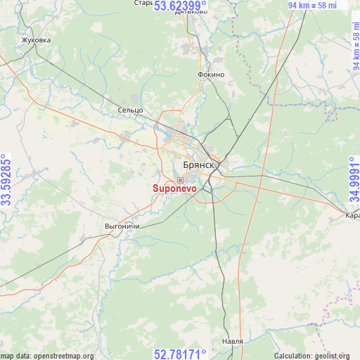
Suponevo GPS coordinates[2]
53° 12' 17.712" North, 34° 17' 45.492" East
| Map corner | latitude | longitude |
|---|---|---|
| Upper-left | 53.62399°, | 33.59285° |
| Center: | 53.20492°, | 34.29597° |
| Lower-right: | 52.78171°, | 34.9991° |
| Map W x H: | 93.7×93.7 km | = 58.2×58.2mi |
| max Lat: | 73.50819° ⇑61.4% North |
| Suponevo: | 53.20492° |
| min Lat: | ⇓38.6% South 41.28413° |
| min Long | Suponevo | max Long |
| -179.12198° | 34.29597° | 179.35046° |
| W 10%⇐ | ⇒90% E |
Elevation
Elevation of Suponevo is 153 m = 502 ft, and this is 49.6 m = 163 ft below average elevation for this country.
| Max E: |
2518 m = 8261 ft | 46.5% |
| Avg. | 202.6 m = 665 ft | |
| Suponevo | 153 m = 502 ft | |
Min E: |
-28 m = -92 ft | 53.5% |
See also: Russia elevation on elevation.city.
Geographical zone
Suponevo is located in North temperate zone (between Tropic of Cancer and the Arctic Circle). Distance of this North polar circle is 1485.3 km =922.9 mi to North.| Distance of | km | miles | from Suponevo |
|---|---|---|---|
| North Pole | 4091.2 | 2542.2 | to North |
| Arctic Circle | 1485.3 | 922.9 | to North |
| Tropic Cancer | 3309.9 | 2056.7 | to South |
| Equator | 5915.8 | 3675.9 | to South |


Nearby cities:
15 places around Suponevo: (largest is in red/bold)
• Belyye Berega
24.5 km =15.2 mi,  89°
89°
• Bryansk
7.3 km =4.5 mi,  43°
43°
• Dobrun’
4 km =2.5 mi,  236°
236°
• Glinishchevo
18.9 km =11.7 mi,  305°
305°
• Ivanovka
16.6 km =10.3 mi,  342°
342°
• Lyubokhna
33.7 km =20.9 mi,  10°
10°
• Net’inka
17.3 km =10.7 mi, 336°
• Ovstug
33.3 km =20.7 mi,  302°
302°
• Putëvka
6 km =3.7 mi,  354°
354°
• Raditsa-Krylovka
13.1 km =8.1 mi,  18°
18°
• Rzhanitsa
35.1 km =21.8 mi,  315°
315°
• Sel’tso
22.2 km =13.8 mi, 324°
• Sven’
17.2 km =10.7 mi,  98°
98°
• Vygonichi
19.3 km =12 mi,  232°
232°
• Zhiryatino
37.7 km =23.4 mi,  273°
273°
Sources, notices
• [Note1] Compared only with cities in Russia existing in our database
• [Src1] Map data: © OpenStreetMap contributors (CC-BY-SA)
• [Src2] Other city data from geonames.org with taken over terms of usage.
• [Src3] Geographical zone / Annual Mean Temperature by Robert A. Rohde @ Wikipedia
