Leningradskaya geodata
Leningradskaya (Krasnodarskiy) is a seat of a second-order administrative division; located in Russia in Europe/Moscow (GMT+3) time zone. With population of 38,712 people, there are 541 cities with bigger population in this country. Compared to other cities in Russia, 83.5% of cities are located further ↑North; 70.5% of cities are located further →East and 89.8% of cities have higher elevation than Leningradskaya. Note1


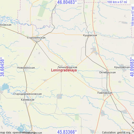
Leningradskaya GPS coordinates[2]
46° 19' 17.04" North, 39° 23' 15.72" East
| Map corner | latitude | longitude |
|---|---|---|
| Upper-left | 46.80483°, | 38.68458° |
| Center: | 46.3214°, | 39.3877° |
| Lower-right: | 45.83366°, | 40.09083° |
| Map W x H: | 108×108 km | = 67.1×67.1mi |
| max Lat: | 73.50819° ⇑83.5% North |
| Leningradskaya: | 46.3214° |
| min Lat: | ⇓16.5% South 41.28413° |
| min Long | Leningradskaya | max Long |
| -179.12198° | 39.3877° | 179.35046° |
| W 29.5%⇐ | ⇒70.5% E |
Elevation
Elevation of Leningradskaya is 29 m = 95 ft, and this is 173.6 m = 570 ft below average elevation for this country.
| Max E: |
2518 m = 8261 ft | 89.8% |
| Avg. | 202.6 m = 665 ft | |
| Leningradskaya | 29 m = 95 ft | |
Min E: |
-28 m = -92 ft | 10.2% |
See also: Russia elevation on elevation.city.
Geographical zone
Leningradskaya is located in North temperate zone (between Tropic of Cancer and the Arctic Circle). Distance of this North polar circle is 2250.7 km =1398.5 mi to North.| Distance of | km | miles | from Leningradskaya |
|---|---|---|---|
| North Pole | 4856.6 | 3017.8 | to North |
| Arctic Circle | 2250.7 | 1398.5 | to North |
| Tropic Cancer | 2544.5 | 1581.1 | to South |
| Equator | 5150.5 | 3200.4 | to South |


Nearby cities:
15 places around Leningradskaya: (largest is in red/bold)
• Atamanskaya
24.9 km =15.5 mi,  130°
130°
• Chelbasskaya
38.1 km =23.7 mi,  181°
181°
• Kanelovskaya
33.3 km =20.7 mi,  333°
333°
• Kanevskaya
42.2 km =26.2 mi,  231°
231°
• Kislyakovskaya
25.8 km =16 mi,  58°
58°
• Krylovskaya
24.4 km =15.2 mi,  195°
195°
• Krylovskaya
44.8 km =27.8 mi,  90°
90°
• Kushchëvskaya
32.5 km =20.2 mi,  35°
35°
• Lenina
41.6 km =25.8 mi, 132°
• Novominskaya
33 km =20.5 mi,  269°
269°
• Novoplatnirovskaya
24 km =14.9 mi,  174°
174°
• Pavlovskaya
36.6 km =22.7 mi,  123°
123°
• Shkurinskaya
29.5 km =18.3 mi,  355°
355°
• Staroderevyankovskaya
38.9 km =24.2 mi,  236°
236°
• Starominskaya
34.8 km =21.6 mi,  311°
311°
Sources, notices
• [Note1] Compared only with cities in Russia existing in our database
• [Src1] Map data: © OpenStreetMap contributors (CC-BY-SA)
• [Src2] Other city data from geonames.org with taken over terms of usage.
• [Src3] Geographical zone / Annual Mean Temperature by Robert A. Rohde @ Wikipedia
