Volgorechensk geodata
Volgorechensk (Kostroma Oblast) is a populated place; located in Russia in Europe/Moscow (GMT+3) time zone. With population of 17,700 people, there are 970 cities with bigger population in this country. Compared to other cities in Russia, 79.8% of cities are located further ↓South; 62.4% of cities are located further →East and 65% of cities have higher elevation than Volgorechensk. Note1


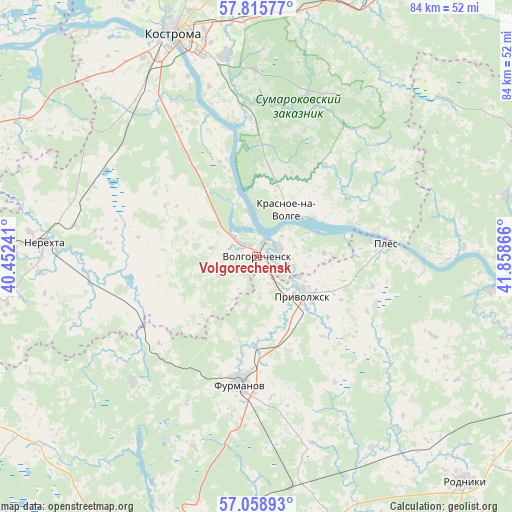
Volgorechensk GPS coordinates[2]
57° 26' 21.516" North, 41° 9' 19.908" East
| Map corner | latitude | longitude |
|---|---|---|
| Upper-left | 57.81577°, | 40.45241° |
| Center: | 57.43931°, | 41.15553° |
| Lower-right: | 57.05893°, | 41.85866° |
| Map W x H: | 84.2×84.2 km | = 52.3×52.3mi |
| max Lat: | 73.50819° ⇑20.2% North |
| Volgorechensk: | 57.43931° |
| min Lat: | ⇓79.8% South 41.28413° |
| min Long | Volgorechensk | max Long |
| -179.12198° | 41.15553° | 179.35046° |
| W 37.6%⇐ | ⇒62.4% E |
Elevation
Elevation of Volgorechensk is 114 m = 374 ft, and this is 88.6 m = 291 ft below average elevation for this country.
| Max E: |
2518 m = 8261 ft | 65% |
| Avg. | 202.6 m = 665 ft | |
| Volgorechensk | 114 m = 374 ft | |
Min E: |
-28 m = -92 ft | 35% |
See also: Russia elevation on elevation.city.
Geographical zone
Volgorechensk is located in North temperate zone (between Tropic of Cancer and the Arctic Circle). Distance of this North polar circle is 1014.5 km =630.4 mi to North.| Distance of | km | miles | from Volgorechensk |
|---|---|---|---|
| North Pole | 3620.4 | 2249.6 | to North |
| Arctic Circle | 1014.5 | 630.4 | to North |
| Tropic Cancer | 3780.7 | 2349.2 | to South |
| Equator | 6386.7 | 3968.5 | to South |


Nearby cities:
15 places around Volgorechensk: (largest is in red/bold)
• Bogorodskoye
44.5 km =27.7 mi,  191°
191°
• Dulyapino
28.7 km =17.8 mi,  225°
225°
• Furmanov
20.8 km =12.9 mi, 187°
• Kamenka
38.6 km =24 mi,  97°
97°
• Kaminskiy
37.3 km =23.2 mi,  149°
149°
• Kosmynino
28.2 km =17.5 mi,  304°
304°
• Kostroma
38.8 km =24.1 mi,  339°
339°
• Krasnoye-na-Volge
9.8 km =6.1 mi,  30°
30°
• Levashevo
44.1 km =27.4 mi, 301°
• Nerekhta
34.8 km =21.6 mi,  273°
273°
• Novopistsovo
43.8 km =27.2 mi,  107°
107°
• Oktyabr’skiy
35.2 km =21.9 mi, 344°
• Plës
21.7 km =13.5 mi,  84°
84°
• Privolzhsk
9.8 km =6.1 mi,  126°
126°
• Staraya Vichuga
47.4 km =29.5 mi, 113°
Sources, notices
• [Note1] Compared only with cities in Russia existing in our database
• [Src1] Map data: © OpenStreetMap contributors (CC-BY-SA)
• [Src2] Other city data from geonames.org with taken over terms of usage.
• [Src3] Geographical zone / Annual Mean Temperature by Robert A. Rohde @ Wikipedia
