Gostagayevskaya geodata
Gostagayevskaya (Krasnodarskiy) is a populated place; located in Russia in Europe/Moscow (GMT+3) time zone. With population of 9,000 people, there are 1653 cities with bigger population in this country. Compared to other cities in Russia, 87.3% of cities are located further ↑North; 81.7% of cities are located further →East and 80.6% of cities have higher elevation than Gostagayevskaya. Note1


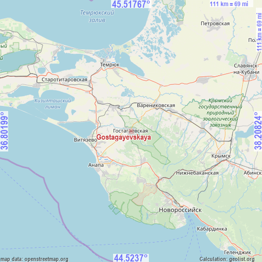
Gostagayevskaya GPS coordinates[2]
45° 1' 22.224" North, 37° 30' 18.396" East
| Map corner | latitude | longitude |
|---|---|---|
| Upper-left | 45.51767°, | 36.80199° |
| Center: | 45.02284°, | 37.50511° |
| Lower-right: | 44.5237°, | 38.20824° |
| Map W x H: | 110.5×110.5 km | = 68.7×68.7mi |
| max Lat: | 73.50819° ⇑87.3% North |
| Gostagayevskaya: | 45.02284° |
| min Lat: | ⇓12.7% South 41.28413° |
| min Long | Gostagayevskaya | max Long |
| -179.12198° | 37.50511° | 179.35046° |
| W 18.3%⇐ | ⇒81.7% E |
Elevation
Elevation of Gostagayevskaya is 69 m = 226 ft, and this is 133.6 m = 438 ft below average elevation for this country.
| Max E: |
2518 m = 8261 ft | 80.6% |
| Avg. | 202.6 m = 665 ft | |
| Gostagayevskaya | 69 m = 226 ft | |
Min E: |
-28 m = -92 ft | 19.4% |
See also: Russia elevation on elevation.city.
Geographical zone
Gostagayevskaya is located in North temperate zone (between Tropic of Cancer and the Arctic Circle). Distance of this North polar circle is 2395.1 km =1488.2 mi to North.| Distance of | km | miles | from Gostagayevskaya |
|---|---|---|---|
| North Pole | 5001 | 3107.5 | to North |
| Arctic Circle | 2395.1 | 1488.2 | to North |
| Tropic Cancer | 2400.2 | 1491.4 | to South |
| Equator | 5006.1 | 3110.6 | to South |


Nearby cities:
15 places around Gostagayevskaya: (largest is in red/bold)
• Anapa
20.5 km =12.7 mi,  224°
224°
• Anapskaya
16.9 km =10.5 mi,  213°
213°
• Blagovetschenskaya
29.5 km =18.3 mi,  277°
277°
• Dzhiginka
17.9 km =11.1 mi,  313°
313°
• Korzhevskiy
25.4 km =15.8 mi,  41°
41°
• Rayevskaya
21.2 km =13.2 mi,  169°
169°
• Strelka
26.7 km =16.6 mi,  319°
319°
• Sukko
25.7 km =16 mi,  194°
194°
• Temryuk
29.1 km =18.1 mi,  341°
341°
• Tsibanobalka
13.5 km =8.4 mi,  249°
249°
• Varenikovskaya
15.3 km =9.5 mi, 44°
• Verkhnebakanskiy
22.7 km =14.1 mi,  148°
148°
• Vinogradnyy
14.9 km =9.3 mi, 284°
• Vityazevo
17.7 km =11 mi,  262°
262°
• Yurovka
12.3 km =7.6 mi,  326°
326°
Sources, notices
• [Note1] Compared only with cities in Russia existing in our database
• [Src1] Map data: © OpenStreetMap contributors (CC-BY-SA)
• [Src2] Other city data from geonames.org with taken over terms of usage.
• [Src3] Geographical zone / Annual Mean Temperature by Robert A. Rohde @ Wikipedia
